File:St Paul's Cray Road - geograph.org.uk - 1715826.jpg
No higher resolution available.
St_Paul's_Cray_Road_-_geograph.org.uk_-_1715826.jpg (640 × 426 pixels, file size: 103 KB, MIME type: image/jpeg)
Captions
Captions
Add a one-line explanation of what this file represents
Summary
edit
| Description |
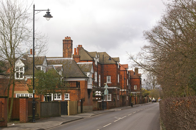
English: St Paul's Cray Road An impressive range of houses on the west side of the road, all designed by George Somers Leigh Clarke. The nearest is Grange Cottage, dating from around 1880, then three similar but asymmetric houses, each with its own name and date plaque, showing a building date of 1878: in order they are Crayfield, Cleeveland and Warren House.
All are grade II listed - for listing particulars of Grange Cottage see http://www.heritagegateway.org.uk/Gateway/Results_Single.aspx?uid=358568&resourceID=5 and for the other three, which are jointly listed, see http://www.heritagegateway.org.uk/Gateway/Results_Single.aspx?uid=358569&resourceID=5. |
| Date | |
| Source | From geograph.org.uk |
| Author | Ian Capper |
| Attribution (required by the license) | Ian Capper / St Paul's Cray Road / |
| Camera location | | View this and other nearby images on: OpenStreetMap |
|---|
_heading:315.00&language=en)
| Object location | | View this and other nearby images on: OpenStreetMap |
|---|
_heading:315.00&language=en)
Licensing
edit

|
This image was taken from the Geograph project collection. See this photograph's page on the Geograph website for the photographer's contact details. The copyright on this image is owned by Ian Capper and is licensed for reuse under the Creative Commons Attribution-ShareAlike 2.0 license.
|
This file is licensed under the Creative Commons Attribution-Share Alike 2.0 Generic license.
Attribution: Ian Capper
- You are free:
- to share – to copy, distribute and transmit the work
- to remix – to adapt the work
- Under the following conditions:
- attribution – You must give appropriate credit, provide a link to the license, and indicate if changes were made. You may do so in any reasonable manner, but not in any way that suggests the licensor endorses you or your use.
- share alike – If you remix, transform, or build upon the material, you must distribute your contributions under the same or compatible license as the original.
File history
Click on a date/time to view the file as it appeared at that time.
| Date/Time | Thumbnail | Dimensions | User | Comment | |
|---|---|---|---|---|---|
| current | 09:28, 5 March 2011 | | 640 × 426 (103 KB) | GeographBot (talk | contribs) | == {{int:filedesc}} == {{Information |description={{en|1=St Paul's Cray Road An impressive range of houses on the west side of the road, all designed by George Somers Leigh Clarke. The nearest is Grange Cottage, dating from around 1880, then three simila |
You cannot overwrite this file.
File usage on Commons
The following page uses this file:
File usage on other wikis
The following other wikis use this file:
- Usage on www.wikidata.org