File:Stache, 1886-1891, bay of Capodistria.TIF

Size of this JPG preview of this TIF file: 679 × 600 pixels. Other resolutions: 272 × 240 pixels | 543 × 480 pixels | 869 × 768 pixels | 1,159 × 1,024 pixels | 2,318 × 2,048 pixels | 2,848 × 2,516 pixels.
Original file (2,848 × 2,516 pixels, file size: 16.18 MB, MIME type: image/tiff, 2 pages)
Captions
Captions
Add a one-line explanation of what this file represents
Summary edit
| Description |
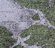
Deutsch: Der Kartenausschnitt zeigt die Altstadt von Capodistria (Koper) und den Mündungsbereich der Rižana (Risano). In beiden Arealen befanden sich Salinen.
English: The map section shows the old town of Capodistria (Koper) and the estuary of the river Rižana (Risano). There were salt works in both areas.
Italiano: La sezione della mappa mostra la città vecchia di Capodistria (Koper) e l'estuario del Rižana (Risano). C'erano saline in entrambe le zone. |
||||
| Date |
Deutsch: geologische Aufnahmearbeiten 1886-1891. Ausgabe 1920, Vermerk am Kartenrand: “In topographischer Hinsicht bis zum Jahre 1915 evidentgestellt.”
English: geological ground survey 1886-1891, map issue 1920. Note at the border of the map on German: ‘Evidenced topographically until 1915’.
Italiano: lavoro di indagine geologico 1886-1891. Edizione 1920, nota sul margine della mappa: "Evidenziato in termini topografici fino all'anno 1915". |
||||
| Source | (photo) Nachtrag zur „Geologischen Spezialkarte der im Reichsrate vertretenen Königreiche und Länder der Österreichisch-ungarischen Monarchie“. Blatt Triest, 1:75.000. (aufgenommen 1886–1891) Geologische Staatsanstalt, Wien 1920. | ||||
| Author | Guido Stache (1833–1921) | ||||
| Permission (Reusing this file) |
|
||||
File history
Click on a date/time to view the file as it appeared at that time.
| Date/Time | Thumbnail | Dimensions | User | Comment | |
|---|---|---|---|---|---|
| current | 16:43, 14 March 2022 |  | 2,848 × 2,516, 2 pages (16.18 MB) | Lysippos (talk | contribs) | {{Information |Description={{de|Der Kartenausschnitt zeigt die Altstadt von Capodistria (Koper) und den Mündungsbereich der Rižana (Risano). In beiden Arealen befanden sich Salinen.}} {{en|The map section shows the old town of Capodistria (Koper) and the estuary of the river Rižana (Risano). There were salt works in both areas.}} {{it|La sezione della mappa mostra la città vecchia di Capodistria (Koper) e l'estuario del Rižana (Risano). C'erano saline in entrambe le zone.}} |Source= (photo) '... |
You cannot overwrite this file.
File usage on Commons
There are no pages that use this file.
File usage on other wikis
The following other wikis use this file:
- Usage on de.wikipedia.org
- Usage on it.wikipedia.org