File:Stadtbahnnetzplan Bielefeld (VERALTET).svg
(Redirected from File:Stadtbahnnetzplan Bielefeld.svg)

Size of this PNG preview of this SVG file: 622 × 600 pixels. Other resolutions: 249 × 240 pixels | 498 × 480 pixels | 797 × 768 pixels | 1,062 × 1,024 pixels | 2,124 × 2,048 pixels | 1,086 × 1,047 pixels.
Original file (SVG file, nominally 1,086 × 1,047 pixels, file size: 7.63 MB)
Captions
Captions
Add a one-line explanation of what this file represents
Summary edit
| Description |
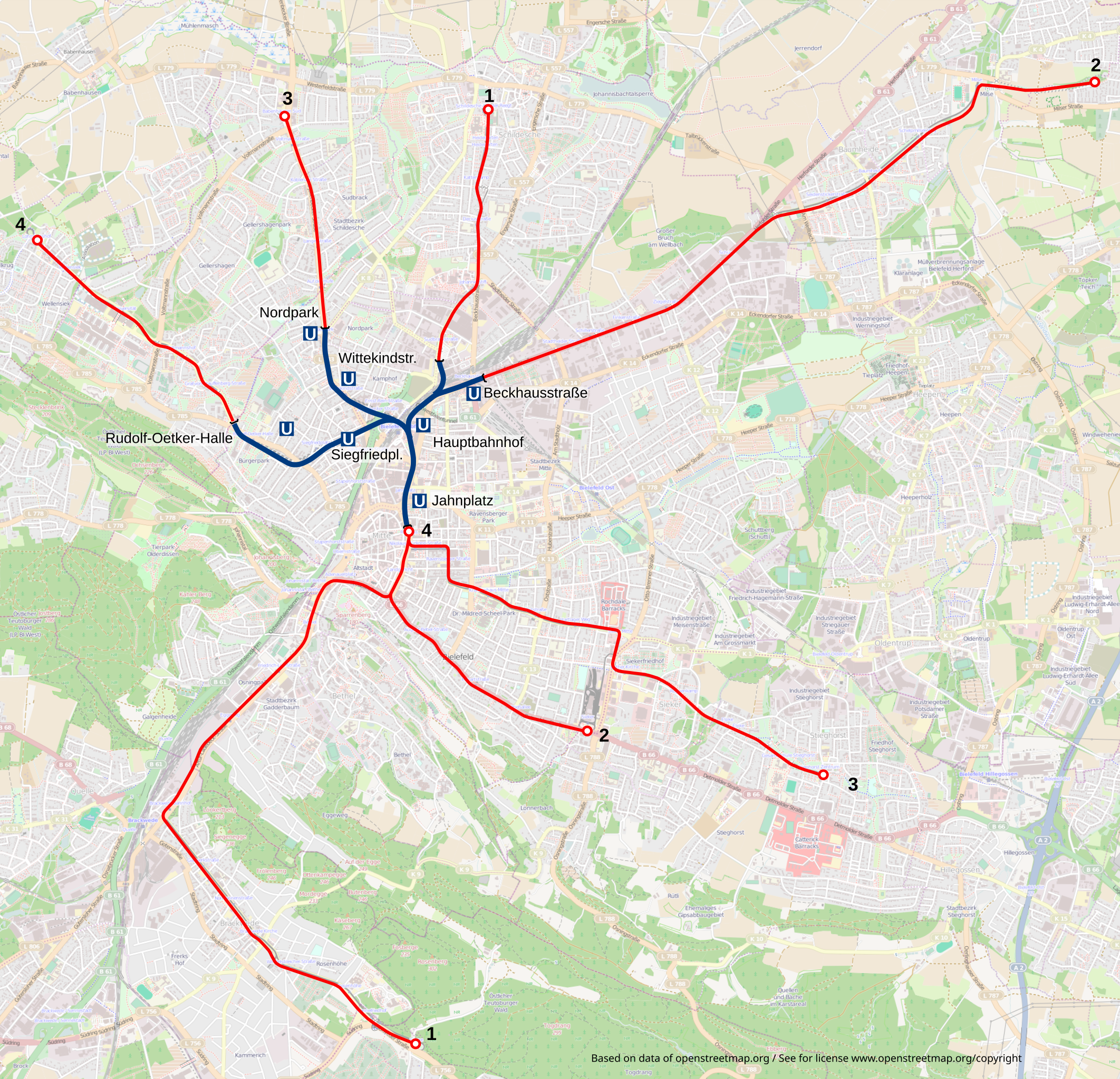
Deutsch: Karte: Netzplan der Stadtbahn Bielefeld
English: Map: Bielefeld light rail network |
||
| Source | Own work, Background map form Openstreetmap (http://www.openstreetmap.org/). | ||
| Author | Arbalete | ||
| Permission (Reusing this file) |
I, the copyright holder of this work, hereby publish it under the following licenses:
This file is licensed under the Creative Commons Attribution-Share Alike 3.0 Unported, 2.5 Generic, 2.0 Generic and 1.0 Generic license.
You may select the license of your choice. |

.svg&action=edit§ion=1)
File history
Click on a date/time to view the file as it appeared at that time.
| Date/Time | Thumbnail | Dimensions | User | Comment | |
|---|---|---|---|---|---|
| current | 22:33, 3 January 2016 | | 1,086 × 1,047 (7.63 MB) | Bielibob (talk | contribs) | OSM Hinweis passend |
| 22:30, 3 January 2016 |  | 1,086 × 1,047 (7.63 MB) | Bielibob (talk | contribs) | Verschobene Linienführung korrigiert OSMHinweis. | |
| 11:44, 20 December 2015 |  | 1,086 × 1,047 (7.63 MB) | Bielibob (talk | contribs) | Korrektur des Linienverlaufs Linie 2 Altenhagen; Bildanpassung | |
| 11:38, 20 December 2015 |  | 1,086 × 1,047 (7.63 MB) | Bielibob (talk | contribs) | Linie 2 bis Altenhagen ergänzt. | |
| 09:56, 24 October 2013 |  | 1,086 × 1,047 (7.63 MB) | Arbalete (talk | contribs) | ??? | |
| 09:44, 24 October 2013 |  | 1,086 × 1,047 (8.03 MB) | Arbalete (talk | contribs) | ? | |
| 09:34, 24 October 2013 |  | 1,086 × 1,047 (8.03 MB) | Arbalete (talk | contribs) | Einige Korrekturen. | |
| 09:13, 24 October 2013 |  | 1,086 × 1,047 (7.75 MB) | Arbalete (talk | contribs) | {{Information |Description ={{de|1=Karte: Netzplan der Stadtbahn Bielefeld}} {{en|1=Map: Bielefeld light rail network}} |Source ={{own}} |Author =Friedrichstrasse |Date = |Permission = |other_v... |
You cannot overwrite this file.
File usage on Commons
The following 8 pages use this file:
- User:Chumwa/OgreBot/Public transport information/2015 December 11-20
- User:Chumwa/OgreBot/Public transport information/2016 January 1-10
- User:Chumwa/OgreBot/Transport Maps/2015 December 11-20
- User:Chumwa/OgreBot/Transport Maps/2016 January 1-10
- User:Nordlicht8/Rail Germany/2013 October 21-31
- User:Nordlicht8/Rail Germany/2015 December 11-20
- User:Nordlicht8/Rail Germany/2016 January 1-10
- File:Stadtbahnnetzplan Bielefeld.svg (file redirect)
File usage on other wikis
The following other wikis use this file:
- Usage on de.wikivoyage.org
.svg&oldid=647992222)