File:Stanford, milestone (a) - geograph.org.uk - 1740173.jpg

Size of this preview: 800 × 600 pixels. Other resolutions: 320 × 240 pixels | 640 × 480 pixels | 1,024 × 768 pixels.
Original file (1,024 × 768 pixels, file size: 243 KB, MIME type: image/jpeg)
Captions
Captions
Add a one-line explanation of what this file represents
Summary
edit_-_geograph.org.uk_-_1740173.jpg&action=edit§ion=1)
| Description |
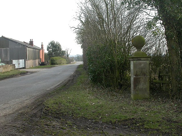
English: Stanford, milestone (a). One of a pair of milestones opposite each other on the road from Stanford to Clay Coton (see also 1740183); this one is on the western side of the road. Square sandstone blocks, surmounted by cornice and ball finial with raised monogram. Distances given to Stanford, Stanford Hall, Swinford, Rugby, Lutterworth, Lilford, and Rugby by a different route. The stone also forms the southern boundary of Stanford parish, and is listed by English Heritage. https://historicengland.org.uk/listing/the-list/list-entry/1287660 |
| Date | |
| Source | From geograph.org.uk |
| Author | Mike Faherty |
| Attribution (required by the license) | Mike Faherty / Stanford, milestone (a) / |
_-_geograph.org.uk_-_1740183.jpg)
| Camera location | | View this and other nearby images on: OpenStreetMap |
|---|
_-_geograph.org.uk_-_1740173.jpg¶ms=052.395950_N_-001.128700_E_globe:Earth_type:camera_source:geograph-osgb36(SP59387790)_heading:180.00&language=en)
| Object location | | View this and other nearby images on: OpenStreetMap |
|---|
_-_geograph.org.uk_-_1740173.jpg¶ms=052.395860_N_-001.128700_E_globe:Earth_class:object_type:object_source:geograph-osgb36(SP59387789)_heading:180.00&language=en)
Licensing
edit_-_geograph.org.uk_-_1740173.jpg&action=edit§ion=2)

|
This image was taken from the Geograph project collection. See this photograph's page on the Geograph website for the photographer's contact details. The copyright on this image is owned by Mike Faherty and is licensed for reuse under the Creative Commons Attribution-ShareAlike 2.0 license.
|
This file is licensed under the Creative Commons Attribution-Share Alike 2.0 Generic license.
Attribution: Mike Faherty
- You are free:
- to share – to copy, distribute and transmit the work
- to remix – to adapt the work
- Under the following conditions:
- attribution – You must give appropriate credit, provide a link to the license, and indicate if changes were made. You may do so in any reasonable manner, but not in any way that suggests the licensor endorses you or your use.
- share alike – If you remix, transform, or build upon the material, you must distribute your contributions under the same or compatible license as the original.
File history
Click on a date/time to view the file as it appeared at that time.
| Date/Time | Thumbnail | Dimensions | User | Comment | |
|---|---|---|---|---|---|
| current | 20:17, 5 March 2011 | | 1,024 × 768 (243 KB) | GeographBot (talk | contribs) | == {{int:filedesc}} == {{Information |description={{en|1=Stanford, milestone (a) One of a pair of milestones opposite each other on the road from Stanford to Clay Coton (see also 1740183); this one is on the western side of the road. Square sandstone |
You cannot overwrite this file.
File usage on Commons
There are no pages that use this file.
_-_geograph.org.uk_-_1740173.jpg&oldid=717631296)