File:StateLibQld 1 263100.jpg

Size of this preview: 710 × 600 pixels. Other resolutions: 284 × 240 pixels | 568 × 480 pixels | 1,000 × 845 pixels.
Original file (1,000 × 845 pixels, file size: 132 KB, MIME type: image/jpeg)
Captions
Captions
Add a one-line explanation of what this file represents
Summary
edit
| Description |
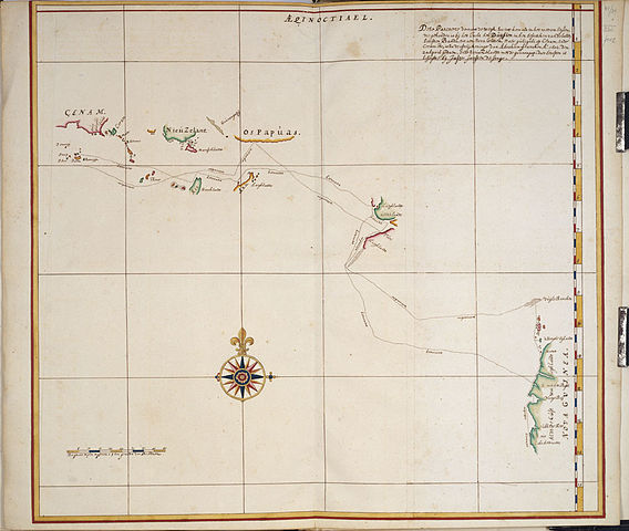
Nederlands: Dese Pascaerte vertoont de wegh, soo int heen als in het weerom seylen, die gehouden is bij het Jacht het Duijfien in het besoecken van de landen beoosten Banda, tot aen Nova Guinea, Maer Guili-guli op Cenam, ende Caram etc, is na de afteijckeninge van Abraam Francken A. 1602. den 20 April gedaen, Ende Nieuw Zelandt met de Gounongapi daer beoosten is beseijlt, bij Jasper Janssen de Jone
English: The map is digitised from a copy made about 1670 of an original map drawn on board the Duyfken during her voyage of discovery along the Australian coast in 1606 from the Atlas Van der Hem, one of the treasures of the Oesterreichische Nationalbibliothek in Vienna, Austria.
The legend of the map states that 'This map shows the route taken by the pinnace Duifien on the outward as well as on the return voyage when she visited the countries east of Banda up to New Guinea'. Of most importance to Queenslanders is the fact that the map identifies the first landfall of the Duyfken on Australian soil as being at 11 degrees 45' S, the present day Pennefather River, where the map states 'R. met het Bosch'. Referenced by Gunter Schilder in his book: Australia unveiled : the share of the Dutch navigators in the discovery of Australia. Amsterdam : Theatrum Orbis Terrarum, 1976, pages 286-287. |
| Date | circa 1670 |
| Source | Copied and digitised from Dese Pascaerte vertoont de wegh, soo int heen als in het weerom seylen, die gehouden is bij het Jacht het Duijfien in het besoecken van de landen beoosten Banda, tot aen Nova Guinea, Maer Guili-guli op Cenam, ende Caram etc, is na de afteijckeninge van Abraham Francken A. 1602. den 20 April gedaen, Ende Nieuw Zelandt met de Gounongapi daer beoosten is beseijlt, bij Jasper Janssen de Jonge [Amsterdam : s.n., 1670] |
| Author | Contributor(s): Oesterreichische Nationalbibliothek. Bildarchiv. |
Licensing
edit
This image or other work is of Australian origin and is now in the public domain because its term of copyright has expired. According to the Australian Copyright Council (ACC), ACC Information Sheet G023v19 (Duration of copyright) (January 2019).1
When using this template, please provide information of where the image was first published and who created it. |
 | |||||||||||||||||||

|
This image has been digitised by the State Library of Queensland, and provided to the Wikimedia Commons as part of a cooperative project. The original photograph is in the public domain. The metadata has been released by State Library of Queensland under the Creative Commons Attribution-Share Alike 2.5 license.
|
File history
Click on a date/time to view the file as it appeared at that time.
| Date/Time | Thumbnail | Dimensions | User | Comment | |
|---|---|---|---|---|---|
| current | 22:38, 8 March 2011 | | 1,000 × 845 (132 KB) | SLQbot (talk | contribs) | =={{int:filedesc}}== {{Information |description={{en|1=Dese Pascaerte vertoont de wegh, soo int heen als in het weerom seylen, die gehouden is bij het Jacht het Duijfien in het besoecken van de landen beoosten Banda, tot aen Nova Guinea, Maer Guili-guli o |
You cannot overwrite this file.
File usage on Commons
There are no pages that use this file.
File usage on other wikis
The following other wikis use this file:
- Usage on en.wikipedia.org
- Usage on incubator.wikimedia.org
- Usage on nl.wikipedia.org
- Usage on vi.wikipedia.org
- Usage on www.wikidata.org