File:State Street and 2100 South.png

Size of this preview: 800 × 557 pixels. Other resolutions: 320 × 223 pixels | 640 × 445 pixels | 839 × 584 pixels.
Original file (839 × 584 pixels, file size: 1.04 MB, MIME type: image/png)
Captions
Captions
Add a one-line explanation of what this file represents
Summary
edit
| Description | |
| Date | aerial photo 1997; diagram 2010 |
| Source | USGS The National Map, via MSR Maps (formerly TerraServer-USA) |
| Author | aerial image: United States Geological Survey (USGS); diagram: User:CL |
Licensing
edit
This image is in the public domain in the United States because it only contains materials that originally came from the United States Geological Survey, an agency of the United States Department of the Interior. For more information, see the official USGS copyright policy.
|
File history
Click on a date/time to view the file as it appeared at that time.
| Date/Time | Thumbnail | Dimensions | User | Comment | |
|---|---|---|---|---|---|
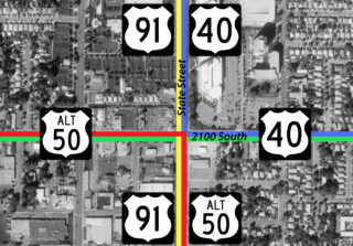
| current | 00:29, 7 October 2010 | | 839 × 584 (1.04 MB) | CountyLemonade (talk | contribs) | {{Information |Description={{en|1={{en|1=Overhead of the intersection of modern-day SR-201 and US-89, including signed designations of routes c. 1960; red line is US-50A, green is SR-201, yellow is US-91 and blue is US-4 |
You cannot overwrite this file.
File usage on Commons
The following 3 pages use this file:
- Commons:Files used on the AARoads Wiki/60
- File:State Street and 2100 South.jpg (file redirect)
- File:State Street and 2100 South 01.png (file redirect)
File usage on other wikis
The following other wikis use this file:
- Usage on en.wikipedia.org