File:Stauberenfist Panorama.jpg

Size of this preview: 800 × 331 pixels. Other resolutions: 320 × 133 pixels | 640 × 265 pixels | 1,024 × 424 pixels | 1,280 × 530 pixels | 2,560 × 1,060 pixels | 5,902 × 2,444 pixels.
Original file (5,902 × 2,444 pixels, file size: 3.44 MB, MIME type: image/jpeg)
Captions
Captions
Add a one-line explanation of what this file represents
| Description |
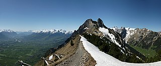
Deutsch: Panoramabild vom Stauberenfirst auf 1693m. Der Rhein bildet hier die Grenzen zu der Schweiz, Liechtenstein und Österreich. Links im Bild der Rätikon, die Schweizer Alvierkette. Die Bildmitte zeigt das Gasthaus Staubern mit der Stauberen Chanzeln. In der rechten Bildhälfte der Altmann, und der Säntis im Alpsteingebirge. Im Vordergrund erstreckt sich vom Kamm des Stauberenfirsts über den südöstlichen Abhang in der linken Bildhälfte die Trockenweide gleichen Namens. Sie ist von nationaler Bedeutung. English: Panoramic view of the Stauberenfirst at 1693m. Here, the Rhine forms the borders to Switzerland, Liechtenstein and Austria. On the left, the Rätikon, the Swiss Alvier mountain. The centre of the picture shows the Staubern inn with the Stauberen Kanzel. In the right half of the picture, the Altmann, and the Säntis in the Alpstein Mountains. In the foreground, the dry grassland of national importance of the same name extends from the crest of the Stauberenfirst over the south-eastern slope in the left half of the picture. Français : Image panoramique du Stauberenfirst à 1693m. Le Rhin forme ici les frontières avec la Suisse, le Liechtenstein et l'Autriche. A gauche de l'image, le Rätikon, le massiv d'Alvier suisse. Le centre de l'image montre l'auberge Staubern avec le Staubern Kanzel. Dans la moitié droite de l'image, le Altmann, et le Säntis dans le massif de l'Alpstein. Au premier plan, la prairies sèche d'importance nationale du même nom s'étend depuis la crête du Stauberenfirst sur le versant sud-est, dans la moitié gauche de l'image. |
||
| Date | |||
| Source | Own work | ||
| Author | böhringer friedrich | ||
| Permission (Reusing this file) |
I, the copyright holder of this work, hereby publish it under the following license: This file is licensed under the Creative Commons Attribution-Share Alike 2.5 Generic license.
|
||
| Protected |
|
This Photo was taken by Böhringer Friedrich.
|
Feel free to use my photos, but please mention me as the author and if you want send me a message. or (rufre@lenz-nenning.at) |
| Camera location | | View this and other nearby images on: OpenStreetMap |
|---|
| Annotations | This image is annotated: View the annotations at Commons |
File history
Click on a date/time to view the file as it appeared at that time.
| Date/Time | Thumbnail | Dimensions | User | Comment | |
|---|---|---|---|---|---|
| current | 21:33, 31 May 2009 | | 5,902 × 2,444 (3.44 MB) | Böhringer (talk | contribs) | {{Information |Description= {{de| Panoramabild vom Stauberenfirst auf 1693m. Der Rhein bildet hier die Grenzen zu der Schweiz, Liechtenstein und Österreich. Links im Bild der Rätikon, die Schweizer [[:de:Alvier (Berg)|Alvier |
You cannot overwrite this file.
File usage on Commons
There are no pages that use this file.