File:Steam Fumarole Field (11870662926).jpg

Size of this preview: 800 × 600 pixels. Other resolutions: 320 × 240 pixels | 640 × 480 pixels | 1,024 × 768 pixels | 1,280 × 960 pixels | 2,560 × 1,920 pixels | 3,648 × 2,736 pixels.
Original file (3,648 × 2,736 pixels, file size: 4.2 MB, MIME type: image/jpeg)
Captions
Captions
Add a one-line explanation of what this file represents
Summary
edit.jpg&action=edit§ion=1)
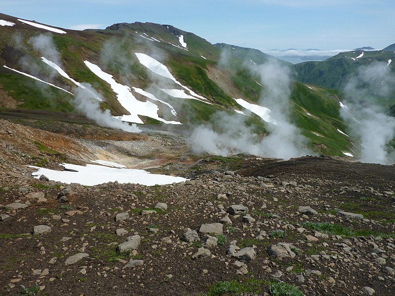
| Description | Steam rises from degassing fumaroles (middle right) and a boiling pool (middle left) on the flank of Akutan Volcano, Akutan Island, Alaska, 2012. Fumaroles are vents from which volcanic gas escapes into the atmosphere. Fumaroles may occur along tiny cracks or long fissures, in chaotic clusters or fields, and on the surfaces of lava flows and thick deposits of pyroclastic flows. They may persist for decades or centuries if they are above a persistent heat source or disappear within weeks to months if they occur atop a fresh volcanic deposit that quickly cools. Credit: Jennifer L. Lewicki , USGS |
| Date | |
| Source | Steam Fumarole Field |
| Author | U.S. Geological Survey from Reston, VA, USA |
Licensing
edit.jpg&action=edit§ion=2)
| This file is made available under the Creative Commons CC0 1.0 Universal Public Domain Dedication. | |
| The person who associated a work with this deed has dedicated the work to the public domain by waiving all of their rights to the work worldwide under copyright law, including all related and neighboring rights, to the extent allowed by law. You can copy, modify, distribute and perform the work, even for commercial purposes, all without asking permission.
|
| This image was originally posted to Flickr by U.S. Geological Survey at https://flickr.com/photos/27784370@N05/11870662926. It was reviewed on 19 January 2018 by FlickreviewR 2 and was confirmed to be licensed under the terms of the cc-zero. |
This image is in the public domain in the United States because it only contains materials that originally came from the United States Geological Survey, an agency of the United States Department of the Interior. For more information, see the official USGS copyright policy.
|
File history
Click on a date/time to view the file as it appeared at that time.
| Date/Time | Thumbnail | Dimensions | User | Comment | |
|---|---|---|---|---|---|
| current | 21:23, 19 January 2018 | | 3,648 × 2,736 (4.2 MB) | Artix Kreiger 2 (talk | contribs) | Transferred from Flickr via Flickr2Commons |
You cannot overwrite this file.
File usage on Commons
There are no pages that use this file.
.jpg&oldid=712509410)