File:Steinhäuser Lageplan.jpg

Size of this preview: 800 × 385 pixels. Other resolutions: 320 × 154 pixels | 806 × 388 pixels.
Original file (806 × 388 pixels, file size: 126 KB, MIME type: image/jpeg)
Captions
Captions
Add a one-line explanation of what this file represents
Summary edit
| Description |
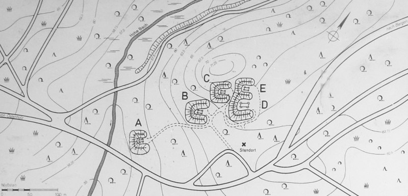
Deutsch: Lageplan 7 Steinhäuser, einer Gruppe von fünf Großsteingräbern in der Lüneburger Heide im NATO-Truppenübungsplatz Bergen-Hohne, Niedersachsen (Deutschland).
English: Site plan of the Sieben Steinhäuser dolmen site, a group of five dolmens on the Lüneburg Heath in the NATO training area of Bergen-Hohne, in the state of Lower Saxony in northern Germany. |
| Date | 24 August 2008 (original upload date) |
| Source | Foto aufgenommen von Benutzer Benutzer:AxelHH, August 2008 |
| Author | Benutzer:AxelHH |
| Object location | | View this and other nearby images on: OpenStreetMap |
|---|
Licensing edit
| I, the copyright holder of this work, release this work into the public domain. This applies worldwide. In some countries this may not be legally possible; if so: I grant anyone the right to use this work for any purpose, without any conditions, unless such conditions are required by law. |
|
The photographical reproduction of this work is covered under the article § 59 of the German copyright law, which states that "It shall be permissible to reproduce, by painting, drawing, photography or cinematography, works which are permanently located on public ways, streets or places and to distribute and publicly communicate such copies. For works of architecture, this provision shall be applicable only to the external appearance."
As with all other “limits of copyright by legally permitted uses”, no changes to the actual work are permitted under § 62 of the German copyright law (UrhG). See Commons:Copyright rules by territory/Germany#Freedom of panorama for more information.
|
Original upload log edit
The original description page was here. All following user names refer to de.wikipedia.
- 2008-08-24 10:18 AxelHH 1030×646× (246948 bytes) {{Information |Beschreibung = Lageplan 7 Steinhäuser |Urheber = [[Benutzer:AxelHH]] |Quelle = Foto aufgenommen von Benutzer [[Benutzer:AxelHH]], August 2008 |Genehmigung = {{Bild-frei}} |Andere Versionen = |Anmerkungen = Foto einer öffentlich aufgeste
File history
Click on a date/time to view the file as it appeared at that time.
| Date/Time | Thumbnail | Dimensions | User | Comment | |
|---|---|---|---|---|---|
| current | 20:24, 6 April 2012 | | 806 × 388 (126 KB) | Cropbot (talk | contribs) | upload cropped version, operated by User:Finavon. Summary: border cropped |
| 12:59, 2 June 2009 |  | 1,030 × 646 (241 KB) | Bermicourt (talk | contribs) | {{Information |Description={{de|Lageplan 7 Steinhäuser}} Site plan of the Sieben Steinhäuser dolmen site in Lower Saxony, Germany. |Source=Transferred from [http://de.wikipedia.org de.wikipedia]<br/> (Original text : ''Foto aufgenommen von Benutzer [[:d |
You cannot overwrite this file.
File usage on Commons
The following page uses this file:
File usage on other wikis
The following other wikis use this file:
- Usage on de.wikipedia.org
- Usage on en.wikipedia.org
- Usage on pl.wikipedia.org
- Usage on www.wikidata.org