File:Stoczek (gmina) location map.png

Size of this preview: 589 × 600 pixels. Other resolutions: 236 × 240 pixels | 471 × 480 pixels | 826 × 841 pixels.
Original file (826 × 841 pixels, file size: 112 KB, MIME type: image/png)
Captions
Captions
Add a one-line explanation of what this file represents
| Description |
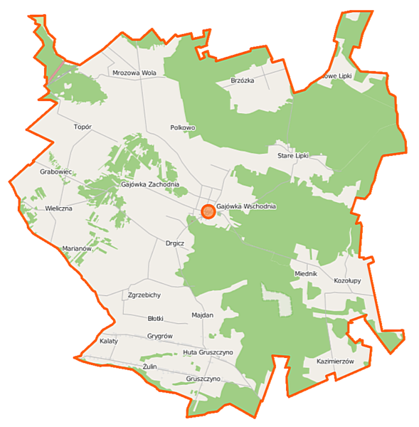
Polski: Mapa gminy Stoczek, Polska
English: Map of Gmina Stoczek, Poland |
|||||||||
| Date | ||||||||||
| Source | You may find a page on the OpenStreetMap wiki page for Stoczek (gmina) | |||||||||
| Creator |
OpenStreetMap contributors OpenStreetMap contributors |
|||||||||
| Permission (Reusing this file) |
OpenStreetMap data is available under the Open Database License (details). Map tiles are licensed under the Creative Commons Attribution-ShareAlike 2.0 license (CC-BY-SA 2.0).
This file is licensed under the Creative Commons Attribution-Share Alike 2.0 Generic license.
|
|||||||||
| Geotemporal data | ||||||||||
| Bounding box |
|
|||||||||
| Georeferencing | If inappropriate please set warp_status = skip to hide. | |||||||||
File history
Click on a date/time to view the file as it appeared at that time.
| Date/Time | Thumbnail | Dimensions | User | Comment | |
|---|---|---|---|---|---|
| current | 11:44, 12 October 2014 | | 826 × 841 (112 KB) | VanWiel (talk | contribs) | {{OpenStreetMap | name = Stoczek (gmina) | location = Stoczek (gmina) | description = {{pl|Mapa gminy Stoczek, Polska}} {{en|Map of Gmina Stoczek, Poland}} | top = 52.6137 | left = 21.7886 | right... |
You cannot overwrite this file.
File usage on Commons
There are no pages that use this file.
File usage on other wikis
The following other wikis use this file:
- Usage on fr.wikipedia.org
- Usage on pl.wikipedia.org
- Stoczek (gmina)
- Błotki
- Drgicz
- Gajówka Wschodnia
- Gajówka Zachodnia
- Grygrów
- Gruszczyno
- Huta Gruszczyno
- Kalaty
- Kozołupy
- Miednik (wieś w województwie mazowieckim)
- Mrozowa Wola
- Nowe Lipki
- Stare Lipki
- Wieliczna (województwo mazowieckie)
- Zgrzebichy
- Brzózka (województwo mazowieckie)
- Polkowo (województwo mazowieckie)
- Żulin (województwo mazowieckie)
- Grabowiec (powiat węgrowski)
- Kałęczyn (powiat węgrowski)
- Marianów (powiat węgrowski)
- Stoczek (powiat węgrowski)
- Topór (powiat węgrowski)
- Kazimierzów (gmina Stoczek)
- Majdan (gmina Stoczek)
- Parafia św. Stanisława Biskupa Męczennika w Stoczku
- Cmentarz żydowski w Stoczku
- Rezerwat przyrody Moczydło (województwo mazowieckie)
- Księżyzna (powiat węgrowski)
- Lubierz-Leśniczówka
- Toboły-Gajówka
- Wycech-Gajówka
- Grabiny (gmina Stoczek)
- Miednik (osada leśna w województwie mazowieckim)
- Kościół św. Stanisława Biskupa Męczennika w Stoczku
- Moduł:Mapa/dane/Stoczek (gmina)
- Działki (Mrozowa Wola)
- Rezerwat przyrody Turzyniec
- Usage on pl.wikibooks.org
_location_map.png&oldid=506879045)