File:Stoner Site fields.jpg

Size of this preview: 800 × 600 pixels. Other resolutions: 320 × 240 pixels | 640 × 480 pixels | 1,024 × 768 pixels | 1,280 × 960 pixels | 2,560 × 1,920 pixels | 2,816 × 2,112 pixels.
Original file (2,816 × 2,112 pixels, file size: 3.15 MB, MIME type: image/jpeg)
Captions
Captions
Add a one-line explanation of what this file represents
|
This is an image of a place or building that is listed on the National Register of Historic Places in the United States of America. Its reference number is 78001143. |
| Camera location | | View this and other nearby images on: OpenStreetMap |
|---|
| Description |
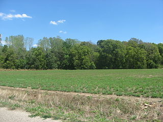
English: Overview of a field at the Stoner Site, located along the eastern side of 1550th Street between 1300th and 1235th Avenues in Lamotte Township, Crawford County, Illinois, United States. Stoner was the location of a village of the Allison-LaMotte culture of Native Americans during the Woodland period; today, it is an archaeological site and listed on the National Register of Historic Places. |
||
| Date | Taken on 18 August 2012 | ||
| Source | Own work | ||
| Author | Nyttend | ||
| Permission (Reusing this file) |
|
File history
Click on a date/time to view the file as it appeared at that time.
| Date/Time | Thumbnail | Dimensions | User | Comment | |
|---|---|---|---|---|---|
| current | 11:56, 5 October 2012 | | 2,816 × 2,112 (3.15 MB) | Nyttend (talk | contribs) | {{NRHP|78001143}} {{Location|39|2|18|N|87|39|20|W}} {{Information |Description={{en|Overview of a field at the {{w|Stoner Site}}, located along the eastern side of 1550th Street between 1300th and 1235th Avenues in {{w|Lamotte Township, Crawford County... |
You cannot overwrite this file.
File usage on Commons
There are no pages that use this file.
File usage on other wikis
The following other wikis use this file:
- Usage on cy.wikipedia.org
- Usage on de.wikipedia.org
- Usage on en.wikipedia.org
- Usage on es.wikipedia.org
- Usage on eu.wikipedia.org
- Usage on fa.wikipedia.org
- Usage on fr.wikipedia.org
- Usage on ur.wikipedia.org
- Usage on vi.wikipedia.org
- Usage on www.wikidata.org