File:Straßenbahn Groß-Lichterfelde Netzplan.png

Size of this preview: 800 × 450 pixels. Other resolutions: 320 × 180 pixels | 640 × 360 pixels | 1,024 × 576 pixels | 1,280 × 720 pixels | 2,560 × 1,439 pixels | 3,646 × 2,050 pixels.
Original file (3,646 × 2,050 pixels, file size: 2.45 MB, MIME type: image/png)
Captions
Captions
Add a one-line explanation of what this file represents
Summary edit
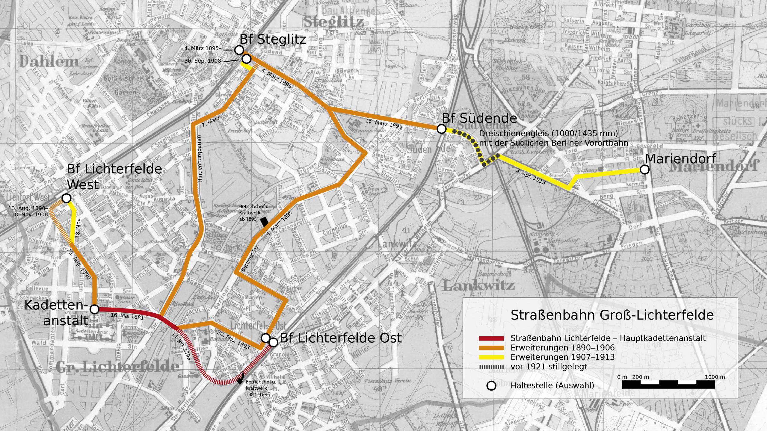
| Description | Karte der Straßenbahn Groß-Lichterfelde (1881–1920) |
| Date | |
| Source | Eigenes Werk basierend auf File:Mende Großer Verkehrs-Plan Berlin und seine Vororte 1907.jpg |
| Author | Christian Liebscher |
Licensing edit
I, the copyright holder of this work, hereby publish it under the following license:
This file is licensed under the Creative Commons Attribution-Share Alike 4.0 International license.
- You are free:
- to share – to copy, distribute and transmit the work
- to remix – to adapt the work
- Under the following conditions:
- attribution – You must give appropriate credit, provide a link to the license, and indicate if changes were made. You may do so in any reasonable manner, but not in any way that suggests the licensor endorses you or your use.
- share alike – If you remix, transform, or build upon the material, you must distribute your contributions under the same or compatible license as the original.
File history
Click on a date/time to view the file as it appeared at that time.
| Date/Time | Thumbnail | Dimensions | User | Comment | |
|---|---|---|---|---|---|
| current | 02:00, 29 December 2022 | | 3,646 × 2,050 (2.45 MB) | Platte (talk | contribs) | Betriebshöfe eingefügt |
| 03:37, 6 January 2022 |  | 3,646 × 2,050 (2.45 MB) | Platte (talk | contribs) | Streckenführung korr. | |
| 02:40, 31 December 2021 |  | 3,646 × 2,050 (2.45 MB) | Platte (talk | contribs) | freie Schriftart | |
| 20:55, 30 December 2021 |  | 3,646 × 2,050 (2.43 MB) | Platte (talk | contribs) | typo | |
| 20:48, 30 December 2021 |  | 3,646 × 2,050 (2.43 MB) | Platte (talk | contribs) | Dreischienenabschnitt korr. | |
| 01:27, 30 December 2021 |  | 3,646 × 2,050 (2.43 MB) | Platte (talk | contribs) | div. optische Verbesserungen | |
| 16:09, 27 December 2021 |  | 2,500 × 1,563 (2.09 MB) | Platte (talk | contribs) | {{Information |Description=Karte der Straßenbahn Groß-Lichterfelde (1881–1920) |Source=Eigenes Werk basierend auf File:Mende Großer Verkehrs-Plan Berlin und seine Vororte 1907.jpg |Date=2021-12-27 |Author= Platte |Permission= |other_versions= }} Category:Tram maps of Berlin Category:Maps of Steglitz-Zehlendorf Category:Images by User:Platte |
You cannot overwrite this file.
File usage on Commons
The following 7 pages use this file:
- User:Chumwa/OgreBot/Public transport information/2021 December 21-31
- User:Chumwa/OgreBot/Public transport information/2022 December 21-31
- User:Chumwa/OgreBot/Public transport information/2022 January 1-10
- User:Chumwa/OgreBot/Transport Maps/2021 December 21-31
- User:Chumwa/OgreBot/Transport Maps/2022 December 21-31
- User:Chumwa/OgreBot/Transport Maps/2022 January 1-10
- User:Platte/Rail transport Berlin/2022 December
File usage on other wikis
The following other wikis use this file: