File:Straßenbahnnetz Kiel.png

Size of this preview: 454 × 600 pixels. Other resolutions: 182 × 240 pixels | 363 × 480 pixels | 581 × 768 pixels | 775 × 1,024 pixels | 1,551 × 2,048 pixels | 7,981 × 10,540 pixels.
Original file (7,981 × 10,540 pixels, file size: 22.23 MB, MIME type: image/png)
Captions
Captions
Add a one-line explanation of what this file represents
Summary
edit
| Warning | The original file is very high-resolution. It might not load properly or could cause your browser to freeze when opened at full size. |
|---|
| Description |
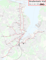
Deutsch: Eine Karte des ehemaligen Straßenbahnnetzes von Kiel auf dem Stand von 1960.
English: A map of the tramway network in Kiel in the year 1960. |
| Date | |
| Source | Karte auf OpenStreetMap |
| Author | Von C21H22N2O2 bearbeitet. |
Licensing
edit
| This work contains information from OpenStreetMap, which is made available under the Open Database License (ODbL).
The ODbL does not require any particular license for maps produced from ODbL data. Prior to 1 August 2020, map tiles produced by the OpenStreetMap Foundation were licensed under the CC-BY-SA-2.0 license. Maps produced by other people may be subject to other licences. |
File history
Click on a date/time to view the file as it appeared at that time.
| Date/Time | Thumbnail | Dimensions | User | Comment | |
|---|---|---|---|---|---|
| current | 18:24, 18 April 2023 | | 7,981 × 10,540 (22.23 MB) | NordNordWest (talk | contribs) | Korrektur Innenstadt |
| 11:18, 31 July 2017 |  | 7,981 × 10,540 (25.73 MB) | C21H22N2O2 (talk | contribs) | Little corrections | |
| 08:55, 31 July 2017 |  | 7,981 × 10,540 (25.73 MB) | C21H22N2O2 (talk | contribs) | Completely redrawed | |
| 10:31, 28 July 2017 |  | 3,346 × 3,954 (13.61 MB) | C21H22N2O2 (talk | contribs) | Kleinigkeiten | |
| 04:59, 28 July 2017 |  | 3,346 × 3,954 (13.61 MB) | C21H22N2O2 (talk | contribs) | weitere Verbesserungen, Ergänzungen | |
| 11:27, 27 July 2017 |  | 3,346 × 3,954 (11.42 MB) | C21H22N2O2 (talk | contribs) | Haltestellennamen | |
| 09:55, 27 July 2017 |  | 3,346 × 3,954 (16.99 MB) | 1970gemini (talk | contribs) | Service | |
| 09:30, 27 July 2017 |  | 3,346 × 3,954 (10.52 MB) | C21H22N2O2 (talk | contribs) | Düppelstraße korrigiert | |
| 17:10, 26 July 2017 |  | 3,346 × 3,954 (10.53 MB) | C21H22N2O2 (talk | contribs) | User created page with UploadWizard |
You cannot overwrite this file.
File usage on Commons
The following 8 pages use this file:
- User:Chumwa/OgreBot/Potential transport maps/2017 July 21-31
- User:Chumwa/OgreBot/Public transport information/2017 July 21-31
- User:Chumwa/OgreBot/Public transport information/2023 April 11-20
- User:Chumwa/OgreBot/Transport Maps/2017 July 21-31
- User:Chumwa/OgreBot/Transport Maps/2023 April 11-20
- User:Chumwa/OgreBot/Travel and communication maps/2017 July 21-31
- User:Clic/Nahverkehr in Deutschland/2023 April 11-20
- Category:Trams in Kiel
File usage on other wikis
The following other wikis use this file:
- Usage on de.wikipedia.org
- Usage on ja.wikipedia.org
- Usage on pl.wikipedia.org
- Usage on www.wikidata.org