File:Straßenbrunnen33 Wannsee Kohlhasenbrück Königsweg (1).jpg

Size of this preview: 450 × 600 pixels. Other resolutions: 180 × 240 pixels | 360 × 480 pixels | 576 × 768 pixels | 768 × 1,024 pixels | 1,536 × 2,048 pixels | 3,085 × 4,113 pixels.
Original file (3,085 × 4,113 pixels, file size: 3.22 MB, MIME type: image/jpeg)
Captions
Captions
Add a one-line explanation of what this file represents
Summary edit
.jpg&action=edit§ion=1)
| Description |
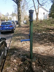
Deutsch: Der Brunnen steht in Kohlhasenbrück direkt an der Landesgrenze (Potsdam Süd-Ost)auf einem Pflastermosaik des südlichen Grünstreifens am Waldstück an Brandenburger Seite, wo einst die Berliner Mauer stand. Der Königsweg geht westlich in die Bernhard-Beyer-Straße über die nach Steinstücken führt. Die Königskappe trägt keine Dekospitze, sondern ist mit einer Platte abgedeckt. Der Brunnen steht im Altlaub, aber er fördert Wasser. |
| Date | |
| Source | Own work |
| Author | Boonekamp (d.i. Günter Haase) |
| Camera location | | View this and other nearby images on: OpenStreetMap |
|---|
.jpg¶ms=052.396976_N_0013.141491_E_globe:Earth_type:camera__&language=en)
Licensing edit
.jpg&action=edit§ion=2)
I, the copyright holder of this work, hereby publish it under the following license:
This file is licensed under the Creative Commons Attribution-Share Alike 4.0 International license.
- You are free:
- to share – to copy, distribute and transmit the work
- to remix – to adapt the work
- Under the following conditions:
- attribution – You must give appropriate credit, provide a link to the license, and indicate if changes were made. You may do so in any reasonable manner, but not in any way that suggests the licensor endorses you or your use.
- share alike – If you remix, transform, or build upon the material, you must distribute your contributions under the same or compatible license as the original.
File history
Click on a date/time to view the file as it appeared at that time.
| Date/Time | Thumbnail | Dimensions | User | Comment | |
|---|---|---|---|---|---|
| current | 18:11, 14 April 2020 | | 3,085 × 4,113 (3.22 MB) | Boonekamp (talk | contribs) | Uploaded own work with UploadWizard |
You cannot overwrite this file.
File usage on Commons
There are no pages that use this file.
.jpg&oldid=770871964)