File:Strait of Gibraltar perspective-it.svg

Size of this PNG preview of this SVG file: 800 × 480 pixels. Other resolutions: 320 × 192 pixels | 1,024 × 615 pixels | 1,280 × 768 pixels | 2,560 × 1,536 pixels | 1,528 × 917 pixels.
Original file (SVG file, nominally 1,528 × 917 pixels, file size: 261 KB)
Captions
Captions
Add a one-line explanation of what this file represents
Summary
edit
| Description |
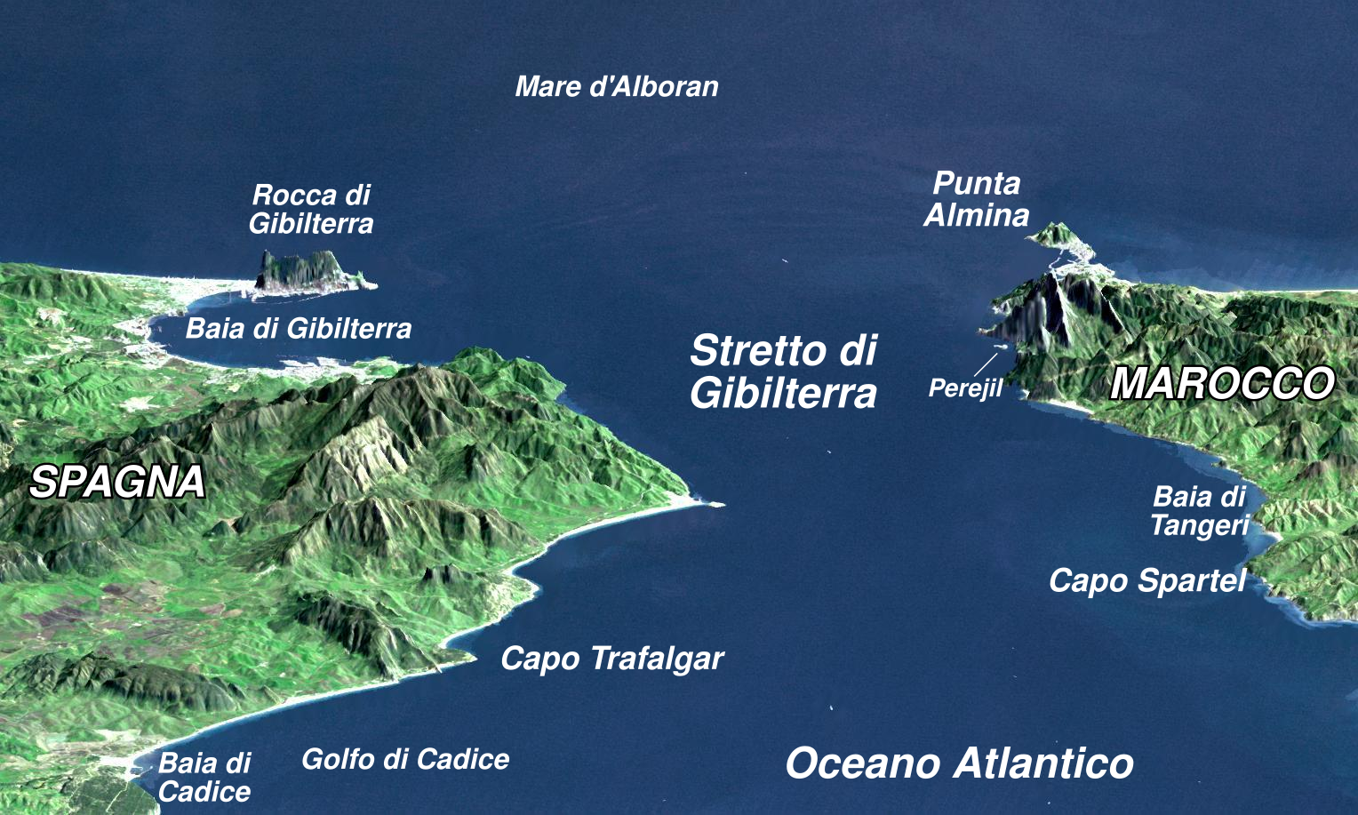
Italiano: Vista dello Stretto di Gibilterra. English: "This perspective view shows the Strait of Gibraltar, which is the entrance to the Mediterranean Sea from the Atlantic Ocean. Europe (Spain) is on the left. Africa (Morocco) is on the right. The Rock of Gibraltar, administered by Great Britain, is the peninsula in the back left." (quotation taken from the more detailed NASA description page)
Français : « Vue en perspective du détroit de Gibraltar, ouvrant sur la mer Méditerranée, avec l'Afrique (Maroc) à droite et l'Europe (Espagne) à gauche. Coté espagnol, on remarque le rocher de Gibraltar, administré par le Royaume-Uni, et côté marocain, Ceuta, territoire espagnol en terre africaine » (Traduction extraite de la description plus détaillée de cette image par la NASA).
Deutsch: Straße von Gibraltar; Aufnahme der NASA Español: Peñón de Gibraltar |
| Date | (UTC) |
| Source |
This file was derived from: Strait of Gibraltar perspective.jpg: |
| Author |
|
| Other versions |
|
Licensing
edit
| This file is in the public domain in the United States because it was solely created by NASA. NASA copyright policy states that "NASA material is not protected by copyright unless noted". (See Template:PD-USGov, NASA copyright policy page or JPL Image Use Policy.) | ||
 |
Warnings:
|
| Camera location | | View this and other nearby images on: OpenStreetMap |
|---|
W3C-validity not checked.

|
This SVG file contains embedded text that can be translated into your language, using any capable SVG editor, text editor or the SVG Translate tool. For more information see: About translating SVG files. |
| This is a retouched picture, which means that it has been digitally altered from its original version. Modifications: fr labels. The original can be viewed here: Strait of Gibraltar perspective.jpg:
|
File history
Click on a date/time to view the file as it appeared at that time.
| Date/Time | Thumbnail | Dimensions | User | Comment | |
|---|---|---|---|---|---|
| current | 20:19, 14 November 2013 | | 1,528 × 917 (261 KB) | Raoli (talk | contribs) | User created page with UploadWizard |
You cannot overwrite this file.
File usage on Commons
There are no pages that use this file.
File usage on other wikis
The following other wikis use this file:
- Usage on it.wikipedia.org