File:Streckenkarte Straßenbahn und Stadtbahn Bochum.png

Size of this preview: 488 × 599 pixels. Other resolutions: 195 × 240 pixels | 391 × 480 pixels | 626 × 768 pixels | 834 × 1,024 pixels | 1,669 × 2,048 pixels | 2,777 × 3,408 pixels.
Original file (2,777 × 3,408 pixels, file size: 5.74 MB, MIME type: image/png)
Captions
Captions
Add a one-line explanation of what this file represents
Summary edit
| Description |
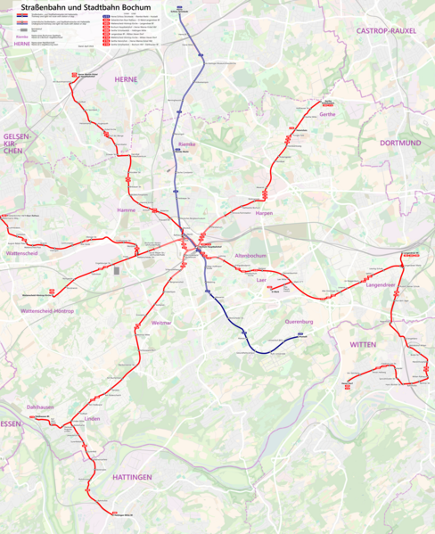
Deutsch: Streckenkarte der Bochumer Straßenbahn (Linien 302, 306, 308, 310 und 318) und der Stadtbahn (Linie U35). Beinhaltet nicht die Gelsenkirchener Strecken, jedoch die von Bochum ausgehenden Strecken nach Herne, Witten und Hattingen. |
|||||||||||||||
| Date | ||||||||||||||||
| Source |
|
|||||||||||||||
| Author | Metrophil |
Licensing edit
I, the copyright holder of this work, hereby publish it under the following license:
This file is licensed under the Creative Commons Attribution-Share Alike 4.0 International license.
- You are free:
- to share – to copy, distribute and transmit the work
- to remix – to adapt the work
- Under the following conditions:
- attribution – You must give appropriate credit, provide a link to the license, and indicate if changes were made. You may do so in any reasonable manner, but not in any way that suggests the licensor endorses you or your use.
- share alike – If you remix, transform, or build upon the material, you must distribute your contributions under the same or compatible license as the original.
File history
Click on a date/time to view the file as it appeared at that time.
| Date/Time | Thumbnail | Dimensions | User | Comment | |
|---|---|---|---|---|---|
| current | 13:18, 22 April 2024 | | 2,777 × 3,408 (5.74 MB) | Metrophil (talk | contribs) | update for changes since 2017 |
| 13:57, 10 October 2017 |  | 3,554 × 4,362 (7.84 MB) | Metrophil (talk | contribs) | small details | |
| 15:05, 8 October 2017 |  | 3,554 × 4,362 (7.78 MB) | Metrophil (talk | contribs) | small correction | |
| 14:37, 8 October 2017 |  | 3,554 × 4,362 (7.78 MB) | Metrophil (talk | contribs) | Tram stop renamed | |
| 14:25, 8 October 2017 |  | 3,554 × 4,362 (7.78 MB) | Metrophil (talk | contribs) | Route 302 extended to Langendreer (S) | |
| 14:55, 27 August 2016 |  | 5,924 × 7,271 (15.54 MB) | Metrophil (talk | contribs) | User created page with UploadWizard |
You cannot overwrite this file.
File usage on Commons
The following 15 pages use this file:
- User:Chumwa/OgreBot/Potential transport maps/2016 August 21-31
- User:Chumwa/OgreBot/Potential transport maps/2017 October 1-10
- User:Chumwa/OgreBot/Public transport information/2016 August 21-31
- User:Chumwa/OgreBot/Public transport information/2017 October 1-10
- User:Chumwa/OgreBot/Public transport information/2024 April 21-30
- User:Chumwa/OgreBot/Transport Maps/2016 August 21-31
- User:Chumwa/OgreBot/Transport Maps/2017 October 1-10
- User:Chumwa/OgreBot/Transport Maps/2024 April 21-30
- User:Chumwa/OgreBot/Travel and communication maps/2016 August 21-31
- User:Chumwa/OgreBot/Travel and communication maps/2017 October 1-10
- User:Chumwa/OgreBot/Travel and communication maps/2024 April 21-30
- User:Clic/Nahverkehr in Deutschland/2024 April 21-30
- User:Holger1959/EN
- User:Nordlicht8/Rail Germany/2017 October 1-10
- User:Nordlicht8/Rail Germany/2024 April 21-30
File usage on other wikis
The following other wikis use this file:
- Usage on de.wikipedia.org
- Usage on de.wikivoyage.org
- Usage on hu.wikipedia.org
- Usage on lmo.wikipedia.org
- Usage on uk.wikipedia.org
- Usage on www.wikidata.org