File:Struve Geodetic Arc-zoom-fr.svg

Size of this PNG preview of this SVG file: 298 × 599 pixels. Other resolutions: 119 × 240 pixels | 239 × 480 pixels | 382 × 768 pixels | 509 × 1,024 pixels | 1,018 × 2,048 pixels | 775 × 1,558 pixels.
Original file (SVG file, nominally 775 × 1,558 pixels, file size: 440 KB)
Captions
Captions
Add a one-line explanation of what this file represents
| Description |
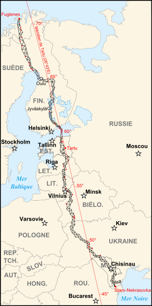
Français : Version réduite de la carte de l'arc géodésique de Struve. Les 34 points rouges correspondent aux sites de mesure classés au patrimoine mondial de l'Unesco English: Zoom version of the map of the Struve Geodetic Arc. The 34 red points are the places registered in the UNESCO World Heritage Site |
||||||||
| Date | |||||||||
| Source | Image:Struve Geodetic Arc-fr.svg | ||||||||
| Author | historicair 00:00, 14 September 2007 (UTC) | ||||||||
| Permission (Reusing this file) |
I, the copyright holder of this work, hereby publish it under the following licenses:
This file is licensed under the Creative Commons Attribution-Share Alike 2.5 Generic, 2.0 Generic and 1.0 Generic license.
You may select the license of your choice. |
||||||||
| Other versions |
[]
|


|
This SVG file contains embedded text that can be translated into your language, using any capable SVG editor, text editor or the SVG Translate tool. For more information see: About translating SVG files. |
File history
Click on a date/time to view the file as it appeared at that time.
| Date/Time | Thumbnail | Dimensions | User | Comment | |
|---|---|---|---|---|---|
| current | 00:00, 14 September 2007 | | 775 × 1,558 (440 KB) | Historicair (talk | contribs) | {{Information |Description={{fr|Arc géodésique de Struve - Version Zoom}} {{en|Struve Geodetic Arc - Zoom Version}} |Source=Image:Struve Geodetic Arc-fr.svg |Date=14/09/2007 |Author=~~~~ |Permission={{self2|GFDL|cc-by-sa-2.5,2.0,1.0}} |other_versio |
You cannot overwrite this file.
File usage on Commons
The following 17 pages use this file:
- Struve Geodetic Arc
- File:Struve Geodetic Arc-fr.svg
- File:Struve Geodetic Arc-he.svg
- File:Struve Geodetic Arc-zoom-af.svg
- File:Struve Geodetic Arc-zoom-cs.svg
- File:Struve Geodetic Arc-zoom-de.svg
- File:Struve Geodetic Arc-zoom-en.svg
- File:Struve Geodetic Arc-zoom-fr.svg
- File:Struve Geodetic Arc-zoom-ka.svg
- File:Struve Geodetic Arc-zoom-lt.svg
- File:Struve Geodetic Arc-zoom-lv.svg
- File:Struve Geodetic Arc-zoom-pl.svg
- File:Struve Geodetic Arc-zoom-ru.svg
- File:Struve Geodetic Arc-zoom-sv.svg
- File:Struve Geodetic Arc-zoom-vi.svg
- File:Struve meridiaan.svg
- Template:Other versions/Struve Geodetic Arc
File usage on other wikis
The following other wikis use this file:
- Usage on de.wikipedia.org
- Usage on el.wikipedia.org
- Usage on fa.wikipedia.org
- Usage on fi.wikipedia.org
- Usage on fr.wikipedia.org
- Usage on fy.wikipedia.org
- Usage on hi.wikipedia.org
- Usage on hr.wikipedia.org
- Usage on id.wikipedia.org
- Usage on it.wikipedia.org
- Usage on ja.wikipedia.org
- Usage on jv.wikipedia.org
- Usage on mai.wikipedia.org
- Usage on ml.wikipedia.org
- Usage on ne.wikipedia.org
- Usage on nl.wikipedia.org
- Usage on no.wikipedia.org
- Usage on pt.wikipedia.org
- Usage on se.wikipedia.org
- Usage on sh.wikipedia.org
- Usage on sk.wikipedia.org
- Usage on sl.wikipedia.org
- Usage on sr.wikipedia.org