File:Stuttgart location map.png
No higher resolution available.
Stuttgart_location_map.png (616 × 572 pixels, file size: 549 KB, MIME type: image/png)
Captions
Captions
Add a one-line explanation of what this file represents
| Description |
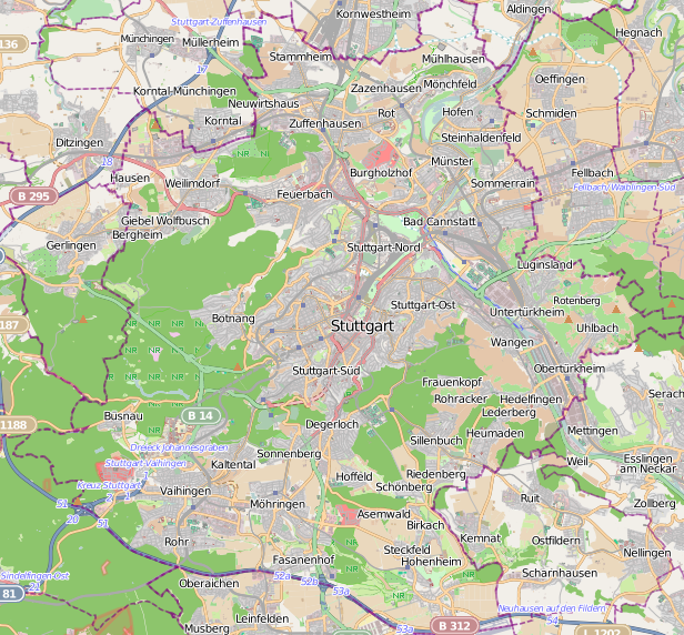
Location map of Stuttgart, Germany This map of Stuttgart was created from OpenStreetMap project data, collected by the community. This map may be incomplete, and may contain errors. Don't rely solely on it for navigation. |
|||||||||
| Date | ||||||||||
| Source | You may find a page on the OpenStreetMap wiki page for Stuttgart | |||||||||
| Creator |
OpenStreetMap contributors |
|||||||||
| Permission (Reusing this file) |
OpenStreetMap data is available under the Open Database License (details). Map tiles are licensed under the Creative Commons Attribution-ShareAlike 2.0 license (CC-BY-SA 2.0).
This file is licensed under the Creative Commons Attribution-Share Alike 2.0 Generic license.
|
|||||||||
| Geotemporal data | ||||||||||
| Bounding box |
|
|||||||||
| Georeferencing | If inappropriate please set warp_status = skip to hide. | |||||||||
File history
Click on a date/time to view the file as it appeared at that time.
| Date/Time | Thumbnail | Dimensions | User | Comment | |
|---|---|---|---|---|---|
| current | 17:39, 6 June 2013 | | 616 × 572 (549 KB) | Powerek38 (talk | contribs) | {{OpenStreetMap |name=Stuttgart |location=Stuttgart |description=Location map of Stuttgart, Germany |top=48.865 |bottom=48.692 |left=9.033 |right=9,316 |date=2013-05-30 |authors= |other_versions= }} Category:Maps of Stuttgart |
You cannot overwrite this file.
File usage on Commons
There are no pages that use this file.
File usage on other wikis
The following other wikis use this file:
- Usage on fr.wikipedia.org
- Usage on pl.wikipedia.org
- MHPArena
- Stuttgart Hauptbahnhof
- Robert Bosch (przedsiębiorstwo)
- Zuffenhausen
- Stuttgart-Bad Cannstatt (stacja kolejowa)
- Stuttgart Österfeld
- Stuttgart Nord
- Stuttgart-Feuerbach (stacja kolejowa)
- Stuttgart Neckarpark
- Muzeum Porsche
- Cerkiew św. Mikołaja w Stuttgarcie
- Parafia św. Mikołaja w Stuttgarcie
- Wilhelma
- Parafia św. Aleksandra Newskiego w Stuttgarcie
- Uniwersytet Hohenheim
- Stuttgart-Münster (stacja kolejowa)
- Stuttgart Neuwirtshaus (Porscheplatz)
- Stuttgart Nürnberger Straße
- Bad Cannstatt
- Botnang
- Degerloch
- Hedelfingen
- Obertürkheim
- Sillenbuch
- Stuttgart-Mitte
- Stuttgart-Nord
- Stuttgart-Ost
- Stuttgart-Süd
- Stuttgart-West
- Untertürkheim
- Weilimdorf
- Birkach (okręg administracyjny Stuttgartu)
- Feuerbach (okręg administracyjny Stuttgartu)
- Möhringen (okręg administracyjny Stuttgartu)
- Mühlhausen (okręg administracyjny Stuttgartu)
- Münster (okręg administracyjny Stuttgartu)
- Plieningen (okręg administracyjny Stuttgartu)
- Stammheim (okręg administracyjny Stuttgartu)
- Vaihingen (okręg administracyjny Stuttgartu)
- Wangen (okręg administracyjny Stuttgartu)
- Stuttgart-Zuffenhausen (stacja kolejowa)
- Moduł:Mapa/dane/Stuttgart
- Stuttgart-Obertürkheim (stacja kolejowa)
- Stuttgart-Untertürkheim (stacja kolejowa)
- Stuttgart Stadtmitte
- Stuttgart Schwabstraße
- Stuttgart Universität
- Schlossplatz (Stuttgart)
- Staatsgalerie Stuttgart
View more global usage of this file.