File:Sucos Osttimors.png
Size of this preview: 800 × 532 pixels. Other resolutions: 320 × 213 pixels | 640 × 425 pixels | 1,024 × 681 pixels | 1,354 × 900 pixels.
Original file (1,354 × 900 pixels, file size: 217 KB, MIME type: image/png)
Captions
Captions
Add a one-line explanation of what this file represents
Summary edit
| Description |
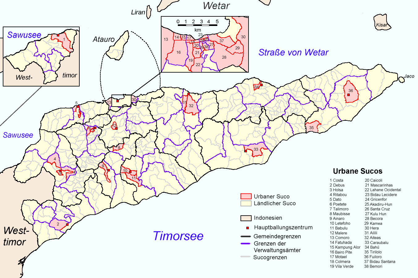
Deutsch: Verwaltungsgrenzen in Osttimor. Grenzen der Distrikte in schwarz, Grenzen der Subdistrikte in lila, Grenzen der urbanen Sucos (rosa) in rot und der anderen Sucos in grau. English: Administrative borders of East Timor. Borders of districts (black), subdistricts (violet) and sucos (gray) of Timor-Leste. Urban sucos are pink with red borders. |
| Date | 03.12.2007 |
| Source | Information map: Direccao Nacional de Estatística Timor-Leste, http://dne.mopf.gov.tl/census/atlas/index.htm; law 6/2003: Diploma Ministerial n.° 6/2003, http://www.mj.gov.tl/jornal/page7/dm0603.htm. |
| Author | Drawn by J. Patrick Fischer. |
| Permission (Reusing this file) |
For free use. |
| Other versions | Derivative works of this file: Sucos Osttimors-2.png |
Licensing edit
I, the copyright holder of this work, hereby publish it under the following licenses:

|
Permission is granted to copy, distribute and/or modify this document under the terms of the GNU Free Documentation License, Version 1.2 or any later version published by the Free Software Foundation; with no Invariant Sections, no Front-Cover Texts, and no Back-Cover Texts. A copy of the license is included in the section entitled GNU Free Documentation License. |
| This file is licensed under the Creative Commons Attribution-Share Alike 3.0 Unported license. | ||
| ||
| This licensing tag was added to this file as part of the GFDL licensing update. |
You may select the license of your choice.
File history
Click on a date/time to view the file as it appeared at that time.
| Date/Time | Thumbnail | Dimensions | User | Comment | |
|---|---|---|---|---|---|
| current | 12:25, 28 May 2016 | | 1,354 × 900 (217 KB) | J. Patrick Fischer (talk | contribs) | Distrikte -> Gemeinden Subdistrikte -> Verwaltungsämter |
| 20:49, 1 March 2011 |  | 1,354 × 900 (215 KB) | J. Patrick Fischer (talk | contribs) | Corrections in subdistrict of Venilale/Baucau district | |
| 14:00, 31 December 2008 |  | 1,354 × 900 (215 KB) | J. Patrick Fischer (talk | contribs) | colours refreshed | |
| 22:45, 30 December 2008 |  | 1,354 × 900 (202 KB) | J. Patrick Fischer (talk | contribs) | Every district checked | |
| 13:07, 29 December 2008 |  | 1,354 × 900 (209 KB) | J. Patrick Fischer (talk | contribs) | Some Suco borders redrawn (check distirct suco maps for further information) | |
| 17:54, 28 December 2008 |  | 1,354 × 900 (212 KB) | J. Patrick Fischer (talk | contribs) | District Viquequqe: Correction of Suco borders. Bibileo has two territories. ( http://unmit.unmissions.org/Portals/UNMIT/Repository/Viqueque%20District_August%202008.a54ed626-8f27-4648-bb5f-092ba42f7ea8.pdf ) | |
| 18:34, 5 January 2008 |  | 1,354 × 900 (193 KB) | J. Patrick Fischer (talk | contribs) | mistake in subdistrict borders in Baucau district corrected | |
| 21:59, 7 December 2007 |  | 1,354 × 900 (213 KB) | J. Patrick Fischer (talk | contribs) | Colours closer to other maps. Some informations (Dili, Tilomar) confirmed at [http://dne.mopf.gov.tl/census/tables/district/ Statistisches Amt Timor-Leste Census 2004], drawn by J. Patrick Fischer | |
| 21:26, 3 December 2007 |  | 1,354 × 900 (182 KB) | J. Patrick Fischer (talk | contribs) | == Beschreibung == {{Information |Description=Borders of districts(black), subdistricts (blue) and sucos (grey) of Timor-Leste. Borders of sucos are green marked in subdistricts, if number of sucos of this map source is not compatible with number of suco |
You cannot overwrite this file.
File usage on Commons
The following page uses this file:
File usage on other wikis
The following other wikis use this file:
- Usage on de.wikipedia.org
- Usage on pt.wikipedia.org