File:Sudan-karte-politisch-nahr-an-nil.png
No higher resolution available.
Sudan-karte-politisch-nahr-an-nil.png (624 × 411 pixels, file size: 155 KB, MIME type: image/png)
Captions
Captions
Add a one-line explanation of what this file represents
Summary
edit
| Description |
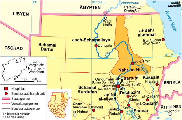
Deutsch: politische Karte des Sudan (Bundesstaat Nahr an-Nil) |
| Date | |
| Source | Own work (Original text: selbst erstellt) |
| Author | Domenico-de-ga |
Licensing
edit

|
Permission is granted to copy, distribute and/or modify this document under the terms of the GNU Free Documentation License, Version 1.2 or any later version published by the Free Software Foundation; with no Invariant Sections, no Front-Cover Texts, and no Back-Cover Texts. A copy of the license is included in the section entitled GNU Free Documentation License. |
| This file is licensed under the Creative Commons Attribution-Share Alike 3.0 Unported license. | ||
| ||
| This licensing tag was added to this file as part of the GFDL licensing update. |
Original upload log
edit
Transferred from de.wikipedia to Commons by Wdwdbot using script bot_filetrans.pl.
The original description page was here. All following user names refer to de.wikipedia.
- 2006-05-21 14:05:10 Domenico-de-ga (158821 Bytes) * Bildbeschreibung: politische Karte des Sudan (Bundesstaat Nahr an-Nil) * Quelle: selbst erstellt * Zeichner: [[Benutzer:Domenico-de-ga|Domenico-de-ga]] * Datum: 21. Mai 2006 {{Bild-GFDL}}
- 2006-05-21 13:09:47 Domenico-de-ga (158947 Bytes) * Bildbeschreibung: politische Karte des Sudan (Bundesstaat Nahr an-Nil) * Quelle: selbst erstellt * Zeichner: [[Benutzer:Domenico-de-ga|Domenico-de-ga]] * Datum: 21. Mai 2006 {{Bild-GFDL}}
- 2006-05-20 18:04:58 Domenico-de-ga (158445 Bytes) * Bildbeschreibung: politische Karte des Sudan (Bundesstaat Nahr an-Nil) * Quelle: selbst erstellt * Zeichner: [[Benutzer:Domenico-de-ga|Domenico-de-ga]] * Datum: 20. Mai 2006 {{Bild-GFDL}}
- 2006-05-20 17:20:17 Domenico-de-ga (158327 Bytes) * Bildbeschreibung: politische Karte des Sudan (Bundesstaat Nahr an-Nil) * Quelle: selbst erstellt * Zeichner: [[Benutzer:Domenico-de-ga|Domenico-de-ga]] * Datum: 20. Mai 2006 {{Bild-GFDL}}
File history
Click on a date/time to view the file as it appeared at that time.
| Date/Time | Thumbnail | Dimensions | User | Comment | |
|---|---|---|---|---|---|
| current | 00:04, 9 May 2015 | | 624 × 411 (155 KB) | Wdwdbot (talk | contribs) | Bot Move: Original uploader of this revision (#4) was Domenico-de-ga at de.wikipedia |
| 00:04, 9 May 2015 |  | 624 × 411 (155 KB) | Wdwdbot (talk | contribs) | Bot Move: Original uploader of this revision (#3) was Domenico-de-ga at de.wikipedia | |
| 00:04, 9 May 2015 |  | 624 × 411 (155 KB) | Wdwdbot (talk | contribs) | Bot Move: Original uploader of this revision (#2) was Domenico-de-ga at de.wikipedia | |
| 00:03, 9 May 2015 |  | 624 × 411 (155 KB) | Wdwdbot (talk | contribs) | Bot Move: Original uploader of this revision (#1) was Domenico-de-ga at de.wikipedia |
You cannot overwrite this file.
File usage on Commons
There are no pages that use this file.