File:Sudanese Internal Conflict.svg

Size of this PNG preview of this SVG file: 684 × 600 pixels. Other resolutions: 274 × 240 pixels | 548 × 480 pixels | 876 × 768 pixels | 1,168 × 1,024 pixels | 2,336 × 2,048 pixels | 1,654 × 1,450 pixels.
Original file (SVG file, nominally 1,654 × 1,450 pixels, file size: 382 KB)
Captions
Captions
Add a one-line explanation of what this file represents
Summary
edit| Description |
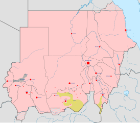
English: Map of the Sudanese conflict. The map image is based on Module:Sudanese Internal Conflict detailed map.
Under control of the Government and Allies
Under control of the Sudanese Awakening Revolutionary Council
Under control of the Sudan Revolutionary Front and allies |
||
| Date | |||
| Source | Own work | ||
| Author | Ali Zifan | ||
| Other versions |
|


.svg)


.svg)


.svg)


Licensing
edit
I, the copyright holder of this work, hereby publish it under the following license:
This file is licensed under the Creative Commons Attribution-Share Alike 4.0 International license.
- You are free:
- to share – to copy, distribute and transmit the work
- to remix – to adapt the work
- Under the following conditions:
- attribution – You must give appropriate credit, provide a link to the license, and indicate if changes were made. You may do so in any reasonable manner, but not in any way that suggests the licensor endorses you or your use.
- share alike – If you remix, transform, or build upon the material, you must distribute your contributions under the same or compatible license as the original.
File history
Click on a date/time to view the file as it appeared at that time.
| Date/Time | Thumbnail | Dimensions | User | Comment | |
|---|---|---|---|---|---|
| current | 18:25, 6 June 2016 | | 1,654 × 1,450 (382 KB) | Ermanarich (talk | contribs) | Update, derived from the Template. |
| 20:20, 3 May 2016 |  | 1,654 × 1,450 (380 KB) | Ermanarich (talk | contribs) | Added towns and villages in South Kordofan under the control of SPLA-N and two contested settlements in Southern Darfur. | |
| 05:50, 21 February 2016 |  | 1,654 × 1,450 (357 KB) | Oganesson007 (talk | contribs) | User created page with UploadWizard |
You cannot overwrite this file.
File usage on Commons
The following 22 pages use this file:
- User:Magog the Ogre/Maps of conflicts/2016 June
- User:Oganesson007/Contributions
- User talk:967Bytes
- User talk:BlueHypercane761
- User talk:BurritoBazooka
- User talk:GamesDiscussion
- User talk:Kohelet
- User talk:Kumdano9
- User talk:Leo Kitbash28
- User talk:Libyanews247
- User talk:LightandDark2000
- User talk:Majed
- User talk:Michael2552
- User talk:Nykterinos
- User talk:Panam2014
- User talk:Pbfreespace3
- User talk:RokerHRO
- User talk:SomeGirl777
- User talk:Turnless
- User talk:Пэйнчик
- User talk:صفاء
- Category:Darfur conflict
File usage on other wikis
The following other wikis use this file:
- Usage on ar.wikipedia.org
- Usage on ast.wikipedia.org
- Usage on azb.wikipedia.org
- Usage on be.wikipedia.org
- Usage on ca.wikipedia.org
- Usage on da.wikipedia.org
- Usage on din.wikipedia.org
- Usage on en.wikipedia.org
- Usage on es.wikipedia.org
- Usage on fa.wikipedia.org
- Usage on fr.wikipedia.org
- Usage on incubator.wikimedia.org
- Usage on pnb.wikipedia.org
- Usage on pt.wikipedia.org
- Usage on ru.wikipedia.org
- Usage on simple.wikipedia.org
- Usage on th.wikipedia.org
- Usage on tr.wikipedia.org
- Usage on uk.wikipedia.org
- Usage on ur.wikipedia.org
- Usage on www.wikidata.org
- Usage on zh.wikipedia.org