File:SugarcaneYield.png

Size of this preview: 800 × 480 pixels. Other resolutions: 320 × 192 pixels | 1,024 × 614 pixels | 1,600 × 960 pixels.
Original file (1,600 × 960 pixels, file size: 480 KB, MIME type: image/png)
Captions
Captions
Add a one-line explanation of what this file represents
Summary edit
| Description |
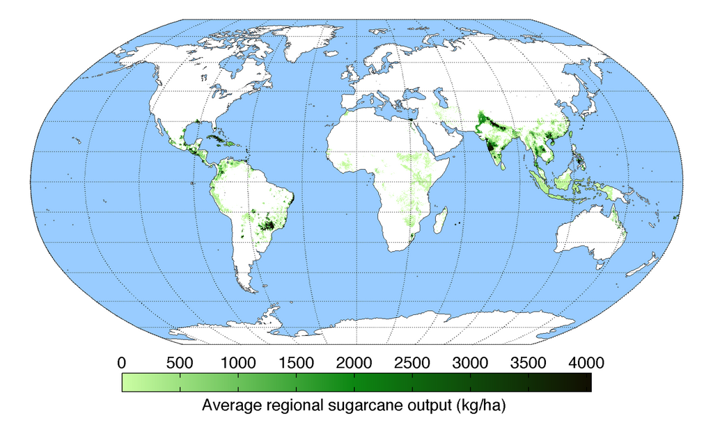
English: Map of sugarcane production (average percentage of land used for its production times average yield in each grid cell) across the world compiled by the University of Minnesota Institute on the Environment with data from: Monfreda, C., N. Ramankutty, and J.A. Foley. 2008. Farming the planet: 2. Geographic distribution of crop areas, yields, physiological types, and net primary production in the year 2000. Global Biogeochemical Cycles 22: GB1022 |
| Date | |
| Source | Own work |
| Author | AndrewMT |
Licensing edit
I, the copyright holder of this work, hereby publish it under the following license:
This file is licensed under the Creative Commons Attribution-Share Alike 3.0 Unported license.
- You are free:
- to share – to copy, distribute and transmit the work
- to remix – to adapt the work
- Under the following conditions:
- attribution – You must give appropriate credit, provide a link to the license, and indicate if changes were made. You may do so in any reasonable manner, but not in any way that suggests the licensor endorses you or your use.
- share alike – If you remix, transform, or build upon the material, you must distribute your contributions under the same or compatible license as the original.
File history
Click on a date/time to view the file as it appeared at that time.
| Date/Time | Thumbnail | Dimensions | User | Comment | |
|---|---|---|---|---|---|
| current | 19:48, 12 May 2010 | | 1,600 × 960 (480 KB) | AndrewMT (talk | contribs) | Bigger resolution Category:Maps Category:Sugar cane Category:Crops |
| 21:34, 17 March 2010 |  | 800 × 500 (192 KB) | AndrewMT (talk | contribs) | reworded title | |
| 21:28, 10 March 2010 |  | 800 × 500 (193 KB) | AndrewMT (talk | contribs) | {{Information |Description={{en|1=Map of sugarcane yield across the world (kg/ha) compiled by the University of Minnesota Institute on the Environment with data from:<br> Monfreda, C., N. Ramankutty, and J.A. Foley. 2008. Farming the planet: 2. Geographic |
You cannot overwrite this file.
File usage on Commons
There are no pages that use this file.
File usage on other wikis
The following other wikis use this file:
- Usage on hak.wikipedia.org
- Usage on hi.wikipedia.org
- Usage on hr.wikipedia.org
- Usage on it.wikipedia.org
- Usage on ko.wikipedia.org
- Usage on mr.wikipedia.org
- Usage on pt.wikipedia.org
- Usage on sd.wikipedia.org
- Usage on sh.wikipedia.org
- Usage on ur.wikipedia.org
- Usage on zh.wikipedia.org