File:Suihei hodo near Odaiko.jpg

Size of this preview: 800 × 600 pixels. Other resolutions: 320 × 240 pixels | 640 × 480 pixels | 1,024 × 768 pixels | 1,280 × 960 pixels | 2,560 × 1,920 pixels | 3,648 × 2,736 pixels.
Original file (3,648 × 2,736 pixels, file size: 3.94 MB, MIME type: image/jpeg)
Captions
Captions
Add a one-line explanation of what this file represents
Summary edit
| Description |
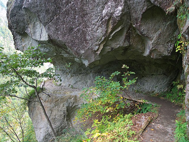
English: Suihei hodo ("flat trail" or "horizontal trail") in Kurobe City, Toyama Prefecture, Japan. The trail runs for about 13 kilometres along the upper part of Kurobe River, and some 300 metres above the river bed. Taken near Odaiko lookout point
日本語: 富山県黒部市の黒部川上流沿いに、川床から約 300 m の高さを約 13 km にわたって延びる水平歩道。「大太鼓」付近にて |
| Date | Taken on 20 October 2010 |
| Source | Own work |
| Author | Yasu (talk) |
| Camera location | | View this and other nearby images on: OpenStreetMap |
|---|
Licensing edit
I, the copyright holder of this work, hereby publish it under the following licenses:

|
Permission is granted to copy, distribute and/or modify this document under the terms of the GNU Free Documentation License, Version 1.2 or any later version published by the Free Software Foundation; with no Invariant Sections, no Front-Cover Texts, and no Back-Cover Texts. A copy of the license is included in the section entitled GNU Free Documentation License. |
This file is licensed under the Creative Commons Attribution-Share Alike 3.0 Unported license.
- You are free:
- to share – to copy, distribute and transmit the work
- to remix – to adapt the work
- Under the following conditions:
- attribution – You must give appropriate credit, provide a link to the license, and indicate if changes were made. You may do so in any reasonable manner, but not in any way that suggests the licensor endorses you or your use.
- share alike – If you remix, transform, or build upon the material, you must distribute your contributions under the same or compatible license as the original.
You may select the license of your choice.
File history
Click on a date/time to view the file as it appeared at that time.
| Date/Time | Thumbnail | Dimensions | User | Comment | |
|---|---|---|---|---|---|
| current | 14:46, 28 November 2010 | | 3,648 × 2,736 (3.94 MB) | Yasu (talk | contribs) | == {{int:filedesc}} == {{information |Description= {{en|''Suihei hodo'' ("flat trail" or "horizontal trail") in Kurobe, Toyama, Japan. The trail runs for about 13 kilometres along the upper part of Kurobe River, and some 300 metres above the river bed. Ta |
You cannot overwrite this file.
File usage on Commons
The following page uses this file:
File usage on other wikis
The following other wikis use this file: