File:Summit Level of Morris Canal from HABS.png

Size of this preview: 764 × 600 pixels. Other resolutions: 306 × 240 pixels | 612 × 480 pixels | 979 × 768 pixels | 1,280 × 1,004 pixels | 2,560 × 2,009 pixels | 3,675 × 2,884 pixels.
Original file (3,675 × 2,884 pixels, file size: 6.07 MB, MIME type: image/png)
Captions
Captions
Add a one-line explanation of what this file represents
| Description |
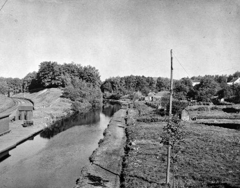
English: Pic of summit level.
HABS says: 48. SUMMIT OF THE MORRIS CANAL, 914 FEET ABOVE MEAN HIGH TIDE AT NEWARK, NEW JERSEY. TRACKS OF THE D, L & W RAILROAD CAN BE SEEN AT LEFT. EDGE OF THE LAKE HOPATCONG STATION IS ALSO VISIBLE AT LEFT. PASSENGERS AND FREIGHT COULD BE TRANSFERRED TO SMALL BOATS FOR TRANSPORT THROUGH THE FEEDER CANAL TO LAKE HOPATCONG. - Morris Canal, Phillipsburg, Warren County, NJ |
|||||
| Date | before 1924 | |||||
| Source |
|
|||||
| Author | Historic American Buildings Survey | |||||
| Permission (Reusing this file) |
|


| Camera location | | View this and other nearby images on: OpenStreetMap |
|---|
File history
Click on a date/time to view the file as it appeared at that time.
| Date/Time | Thumbnail | Dimensions | User | Comment | |
|---|---|---|---|---|---|
| current | 23:18, 13 January 2014 | | 3,675 × 2,884 (6.07 MB) | Bonnachoven (talk | contribs) | Crop, straighten, and adjust levels. |
| 05:36, 13 January 2014 |  | 5,000 × 3,555 (7.95 MB) | Bonnachoven (talk | contribs) | {{Information |Description ={{en|1=Pic of summit level. HABS says: 48. SUMMIT OF THE MORRIS CANAL, 914 FEET ABOVE MEAN HIGH TIDE AT NEWARK, NEW JERSEY. TRACKS OF THE D, L & W RAILROAD CAN BE SEEN AT LEFT. EDGE OF THE LAKE HOPATCONG STATION IS ALSO... |
You cannot overwrite this file.
File usage on Commons
There are no pages that use this file.
File usage on other wikis
The following other wikis use this file:
- Usage on en.wikipedia.org