File:Supermarine Spitfire Mk.I 1940 (43267203170).jpg

Original file (4,722 × 2,189 pixels, file size: 5.21 MB, MIME type: image/jpeg)
Captions
Captions
Summary
edit.jpg&action=edit§ion=1)
| Description |
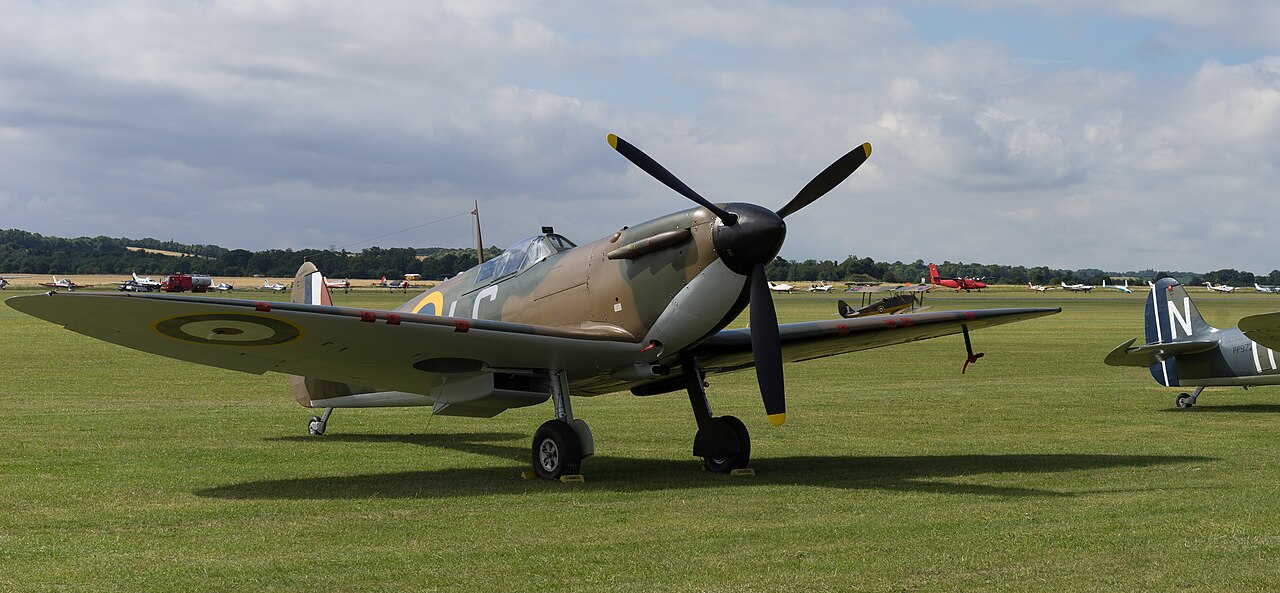
G-CGUK s/n 6S-75531 X4650 was built in 1940 as part of contract 19713/39 by Vickers Armstrong's (Supermarine) Ltd. at Woolston and was first test flown at Eastleigh on 23 October 1940. -The X4650 was delivered to the RAF No. 24 MU (Maintenance Unit) at Royal Air Force station Ternhill in Shropshire, England, on 25 October 1940.
-On 28 December 1940, Spitfire X4650 and Spitfire X4276 of 54 Squadron were undertaking a training exercise when they collided at 12,000 feet, the X4650 cut through the tail section of the other aircraft. The aircraft then crashed into the bank of the River Leven at Red Hall Farm, Kirklevington. The pilot landed at Kirklevington Hall, North Yorkshire. Following the crash Cat.W/FA damage (Write-off/ Flying Accident) was recorded and Spitfire X4650 was struck off charge on 4 January 1941. -The wreckage of the X4650 was discovered in the long, hot summer of 1976. -On 10 February 2011, the Spitfire Mk.I was registered G-CGUK in the UK with Peter Monk Ltd as Vickers Supermarine Spitfire I s/n 6S-75531. First post restoration flight of the Spitfire in the Royal Air Force colours 'X4650/KLA' was from Biggin Hill in March 2012. -On 11 September 2012, the aircraft was registered as chartered with Comanche Warbirds Ltd, Barnet. The Spitfire Mk.I is owned by Comanche Fighters, Houston, Texas, and is based based at Duxford. -On 17 May 2016, the CAA permitted flying in Royal Air Force colours with Code:LC and Serial:R9612 on the aircraft. <a href="https://www.flyinglegends.com/aircraft/spitfire-mki.html" rel="nofollow">www.flyinglegends.com/aircraft/spitfire-mki.html</a> |
| Date | |
| Source | Supermarine Spitfire Mk.I 1940 |
| Author | Falcon® Photography from France, France |
| Camera location | | View this and other nearby images on: OpenStreetMap |
|---|
.jpg¶ms=052.093113_N_0000.130505_E_globe:Earth_type:camera_source:Flickr_&language=en)
Licensing
edit.jpg&action=edit§ion=2)
- You are free:
- to share – to copy, distribute and transmit the work
- to remix – to adapt the work
- Under the following conditions:
- attribution – You must give appropriate credit, provide a link to the license, and indicate if changes were made. You may do so in any reasonable manner, but not in any way that suggests the licensor endorses you or your use.
- share alike – If you remix, transform, or build upon the material, you must distribute your contributions under the same or compatible license as the original.
| This image was originally posted to Flickr by Falcon_33 at https://flickr.com/photos/93592003@N04/43267203170. It was reviewed on 20 December 2020 by FlickreviewR 2 and was confirmed to be licensed under the terms of the cc-by-sa-2.0. |
File history
Click on a date/time to view the file as it appeared at that time.
| Date/Time | Thumbnail | Dimensions | User | Comment | |
|---|---|---|---|---|---|
| current | 13:38, 20 December 2020 | | 4,722 × 2,189 (5.21 MB) | Eyes Roger (talk | contribs) | Transferred from Flickr via #flickr2commons |
You cannot overwrite this file.
File usage on Commons
There are no pages that use this file.
File usage on other wikis
The following other wikis use this file:
- Usage on fr.wikipedia.org
.jpg&oldid=895585851)