File:Surses as seen from Roccabella.jpg

Size of this preview: 800 × 468 pixels. Other resolutions: 320 × 187 pixels | 640 × 374 pixels | 1,024 × 599 pixels | 1,280 × 749 pixels | 2,310 × 1,351 pixels.
Original file (2,310 × 1,351 pixels, file size: 446 KB, MIME type: image/jpeg)
Captions
Captions
Add a one-line explanation of what this file represents
Summary
edit| Description |
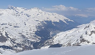
English: Surses, picture taken from Roccabella (Surses, Grison, Switzerland)
Deutsch: Surses, aufgenommen von der Roccabella (Surses, Graubünden, Schweiz)
Rumantsch: Surses, piglia se davent dalla Roccabella (Surses, Grischun, Svizra)
Italiano: Sures, fotografato da la Roccabella (Surses, Grigioni, Svizzera) |
||
| Date | |||
| Source |
Own work
|
||
| Author | Capricorn4049 | ||
| Permission (Reusing this file) |
|
||
| Other versions |

| Camera location | | View this and other nearby images on: OpenStreetMap |
|---|
| Object location | | View this and other nearby images on: OpenStreetMap |
|---|
Licensing
edit
I, the copyright holder of this work, hereby publish it under the following license:
This file is licensed under the Creative Commons Attribution-Share Alike 4.0 International license.
- You are free:
- to share – to copy, distribute and transmit the work
- to remix – to adapt the work
- Under the following conditions:
- attribution – You must give appropriate credit, provide a link to the license, and indicate if changes were made. You may do so in any reasonable manner, but not in any way that suggests the licensor endorses you or your use.
- share alike – If you remix, transform, or build upon the material, you must distribute your contributions under the same or compatible license as the original.
File history
Click on a date/time to view the file as it appeared at that time.
| Date/Time | Thumbnail | Dimensions | User | Comment | |
|---|---|---|---|---|---|
| current | 23:13, 19 April 2019 | | 2,310 × 1,351 (446 KB) | Capricorn4049 (talk | contribs) | File:Roccabella Panorama.jpg cropped 89 % horizontally, 24 % vertically using CropTool with lossless mode. |
You cannot overwrite this file.
File usage on Commons
The following page uses this file:
File usage on other wikis
The following other wikis use this file:
- Usage on de.wikipedia.org