File:Survey of Palestine, Natanya - block plan index (FL27964884 2630755).jpg

Size of this preview: 431 × 600 pixels. Other resolutions: 172 × 240 pixels | 345 × 480 pixels | 552 × 768 pixels | 736 × 1,024 pixels | 1,471 × 2,048 pixels | 12,432 × 17,303 pixels.
Original file (12,432 × 17,303 pixels, file size: 279.28 MB, MIME type: image/jpeg)
Captions
Captions
Add a one-line explanation of what this file represents
Summary
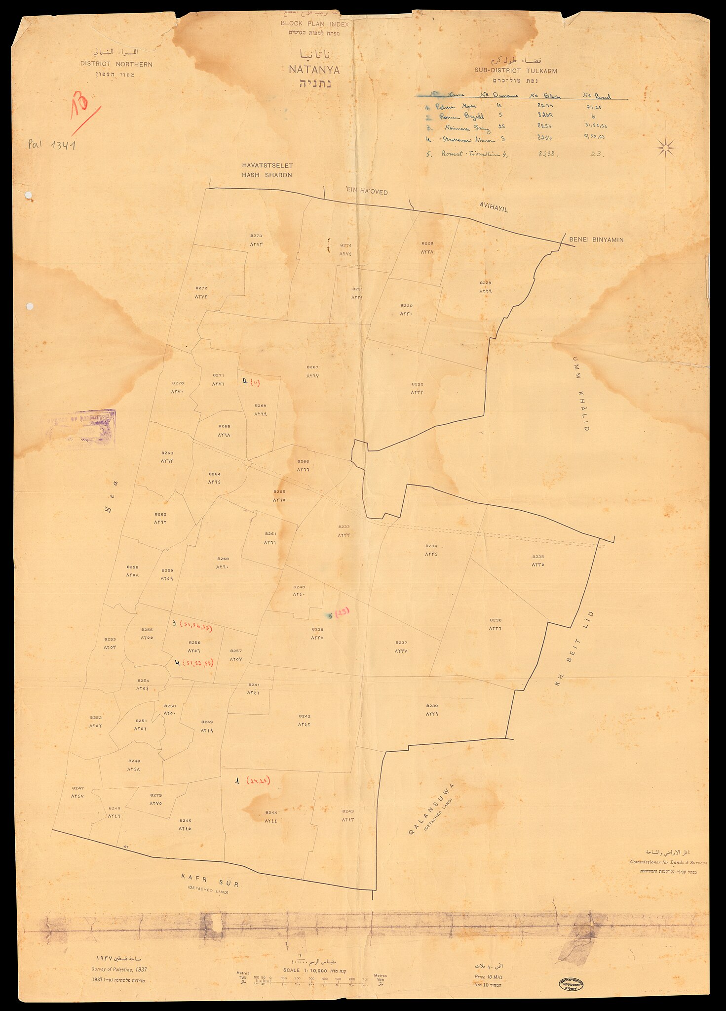
edit| Survey of Palestine: Natanya - block plan index
( |
||||||||||||||||||||||||
|---|---|---|---|---|---|---|---|---|---|---|---|---|---|---|---|---|---|---|---|---|---|---|---|---|
| Artist |
|
|||||||||||||||||||||||
| Title |
Natanya - block plan index |
|||||||||||||||||||||||
| Publisher |
Survey of Palestine |
|||||||||||||||||||||||
| Description |
Natanya - block plan index. |
|||||||||||||||||||||||
| Language | English, Hebrew, Arabic | |||||||||||||||||||||||
| Publication date | 1937 | |||||||||||||||||||||||
| Medium | 1 sheet ; | |||||||||||||||||||||||
| Dimensions | height: 71 cm (27.9 in); width: 50 cm (19.6 in) | |||||||||||||||||||||||
| Collection |
|
|||||||||||||||||||||||
| Current location |
|
|||||||||||||||||||||||
| Place of publication | unknown | |||||||||||||||||||||||
| search Merhav catalog | unknown | |||||||||||||||||||||||
| Notes | District Northern, sub-district Tulkarm; Cadastral map; מפת גושים | |||||||||||||||||||||||
| scale | 1:10,000 cm | |||||||||||||||||||||||
| IE PID | IE27964882 | |||||||||||||||||||||||
| Rosetta filename | FL27964884 | |||||||||||||||||||||||
| NNL item ID (P3959) | 990026307550205171 | |||||||||||||||||||||||
| search Merhav catalog | English, Hebrew, Arabic, Survey of Palestine | |||||||||||||||||||||||
| search Merhav catalog | נתניהنتانيا - مجموعة ترتيب للوح القطع : قضاء طولكرم، اللواء الشمالي مساحة فلسطينللخريطة عنوان ثان بالعربية:מחוז הצפוןנפת טול כרםטול כרםSurvey of Palestine | |||||||||||||||||||||||
| Source/Photographer |
|
|||||||||||||||||||||||
| Other versions | ||||||||||||||||||||||||
| Jpg / Tif version |
|
|||||||||||||||||||||||

.jpg)

.jpg&action=edit§ion=1)
Licensing
edit.jpg&action=edit§ion=2)
This work created by the United Kingdom Government is in the public domain.
This is because it is one of the following:
HMSO has declared that the expiry of Crown Copyrights applies worldwide (ref: HMSO Email Reply)
|
 |
File history
Click on a date/time to view the file as it appeared at that time.
| Date/Time | Thumbnail | Dimensions | User | Comment | |
|---|---|---|---|---|---|
| current | 05:24, 3 August 2023 | | 12,432 × 17,303 (279.28 MB) | Geagea (talk | contribs) | pattypan 22.03 |
You cannot overwrite this file.
File usage on Commons
The following 2 pages use this file:
.jpg&oldid=850006354)