File:Survey of Telegraph Line from Frere Town-Mombassa to Malindi. East Africa. (WOMAT-AFR-BEA-209-1-19).jpg

Size of this preview: 380 × 599 pixels. Other resolutions: 152 × 240 pixels | 304 × 480 pixels | 487 × 768 pixels | 650 × 1,024 pixels | 1,300 × 2,048 pixels | 5,534 × 8,719 pixels.
Original file (5,534 × 8,719 pixels, file size: 20.91 MB, MIME type: image/jpeg)
Captions
Captions
Add a one-line explanation of what this file represents
Summary
edit| Title |
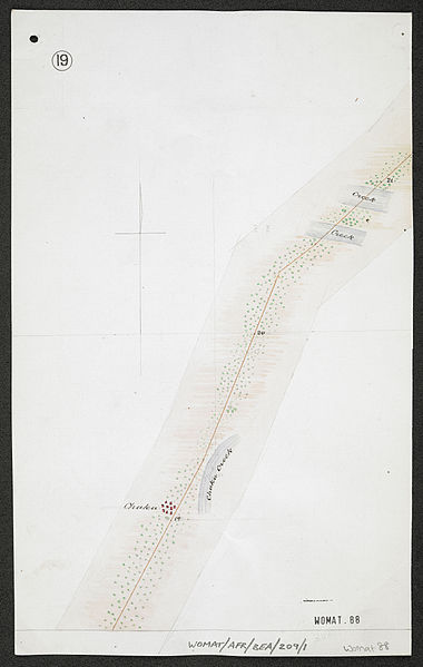
'Survey of Telegraph Line from Frere Town-Mombassa to Malindi. East Africa.' |
|||||||||
| Description |
Shows a route along the eastern coast of East Africa Protectorate, indicating hydrology, settlements, roads and vegetation |
|||||||||
| British Library Shelfmark | WOMAT/AFR/BEA/209/1/19 | |||||||||
| Locations Depicted | Mombassa, East Africa Protectorate | |||||||||
| Centre Point Coordinates | -3.6190,39.9132 | |||||||||
| Date | ||||||||||
| Source |
|
|||||||||
| Creator |
Wilson, David James, c 1858-1913, colonial administrator, Surveyor |
|||||||||
| Permission (Reusing this file) |
|
|||||||||
| Geotemporal data | ||||||||||
| Map location | British East Africa | |||||||||
| Scale | 1:15,840 | |||||||||
| Bounding box |
|
|||||||||
| Georeferencing | If inappropriate please set warp_status = skip to hide. | |||||||||
| Archival data | ||||||||||
| Collection | ||||||||||
| Dimensions | 33 x 25cm | |||||||||
| Medium | Manuscript: coloured ink, pencil and watercolour on paper | |||||||||
| Notes | For more information please see the British Library’s Collection Guide to the War Office Archive. | |||||||||

_(St_Edwards_Crown).svg)


.jpg&action=edit§ion=1)
.jpg¶ms=-3.2131_N_39.6958_E_)
.jpg¶ms=-3.2131_N_40.1306_E_)
.jpg¶ms=-4.0248_N_39.6958_E_)
.jpg¶ms=-4.0248_N_40.1306_E_)
File history
Click on a date/time to view the file as it appeared at that time.
| Date/Time | Thumbnail | Dimensions | User | Comment | |
|---|---|---|---|---|---|
| current | 01:56, 24 November 2015 | | 5,534 × 8,719 (20.91 MB) | Ndalyrose (talk | contribs) | GWToolset: Creating mediafile for Ndalyrose. |
You cannot overwrite this file.
File usage on Commons
The following page uses this file:
.jpg&oldid=479568680)