File:Surveying coastal erosion in East Yorkshire (geograph 7206967).jpg

Size of this preview: 800 × 565 pixels. Other resolutions: 320 × 226 pixels | 640 × 452 pixels | 1,024 × 723 pixels | 1,280 × 904 pixels | 2,560 × 1,808 pixels | 4,968 × 3,508 pixels.
Original file (4,968 × 3,508 pixels, file size: 4.07 MB, MIME type: image/jpeg)
Captions
Captions
Add a one-line explanation of what this file represents
Summary
edit.jpg&action=edit§ion=1)
| Description |
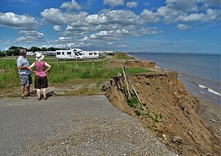
English: Surveying coastal erosion in Ulrome, East Riding of Yorkshire, England. At East End, Ulrome. This is perhaps the worst section of the English coastline for erosion. The soft boulder clay deposited twelve thousand years ago in the last Ice Age offers little resistance to chomping North Sea waves. |
| Date | |
| Source | From geograph.org.uk |
| Author | Neil Theasby |
| Permission (Reusing this file) |
Creative Commons Attribution Share-alike license 2.0 |
| Attribution (required by the license) | Neil Theasby / Surveying coastal erosion in East Yorkshire / |
| Camera location | | View this and other nearby images on: OpenStreetMap |
|---|
.jpg¶ms=053.996232_N_-000.208681_E_globe:Earth_type:camera_source:geograph-osgb36(TA1752657062)_heading:22.00&language=en)
| Object location | | View this and other nearby images on: OpenStreetMap |
|---|
.jpg¶ms=053.996390_N_-000.208610_E_globe:Earth_class:object_type:object_source:geograph-osgb36(TA17535708)_heading:22.00&language=en)
Licensing
edit.jpg&action=edit§ion=2)

|
This image was taken from the Geograph project collection. See this photograph's page on the Geograph website for the photographer's contact details. The copyright on this image is owned by Neil Theasby and is licensed for reuse under the Creative Commons Attribution-ShareAlike 2.0 license.
|
This file is licensed under the Creative Commons Attribution-Share Alike 2.0 Generic license.
Attribution: Neil Theasby
- You are free:
- to share – to copy, distribute and transmit the work
- to remix – to adapt the work
- Under the following conditions:
- attribution – You must give appropriate credit, provide a link to the license, and indicate if changes were made. You may do so in any reasonable manner, but not in any way that suggests the licensor endorses you or your use.
- share alike – If you remix, transform, or build upon the material, you must distribute your contributions under the same or compatible license as the original.
File history
Click on a date/time to view the file as it appeared at that time.
| Date/Time | Thumbnail | Dimensions | User | Comment | |
|---|---|---|---|---|---|
| current | 00:12, 23 March 2024 | | 4,968 × 3,508 (4.07 MB) | Keith D (talk | contribs) | == {{int:filedesc}} == {{Information |Description={{en|1=Surveying coastal erosion in Ulrome, East Riding of Yorkshire, England.<br />At East End, Ulrome. This is perhaps the worst section of the English coastline for erosion. The soft boulder clay deposited twelve thousand years ago in the last Ice Age offers little resistance to chomping North Sea waves.}} |Source=From [https://www.geograph.org.uk/photo/7206967 geograph.org.uk] |Date=2022-06-2... |
You cannot overwrite this file.
File usage on Commons
There are no pages that use this file.
.jpg&oldid=862706477)