File:SurveyorGeneralsCorner.svg

Size of this PNG preview of this SVG file: 450 × 600 pixels. Other resolutions: 180 × 240 pixels | 360 × 480 pixels | 576 × 768 pixels | 768 × 1,024 pixels | 1,536 × 2,048 pixels | 750 × 1,000 pixels.
Original file (SVG file, nominally 750 × 1,000 pixels, file size: 5 KB)
Captions
Captions
Add a one-line explanation of what this file represents
Summary
edit| Description |
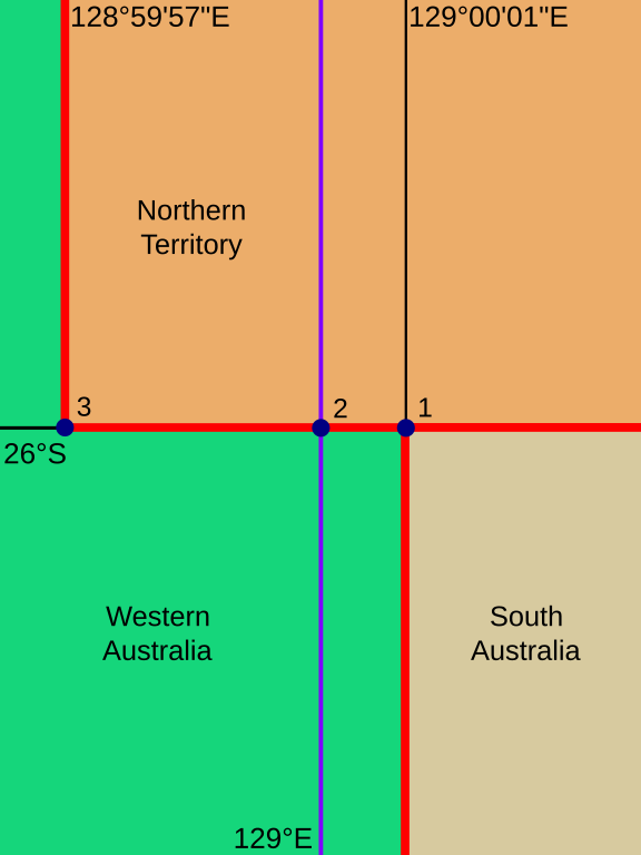
English: Borders of Western Australia, South Australia and the Northern Territory in the vicinity of Surveyor General's Corner.
Nederlands:
|
| Date | 7 January 2007 (original upload date) |
| Source | Own work based on: SurveyorGeneralsCorner.jpg by Walter Holden-Belmont |
| Author | Vectorization: Alhadis |
| Other versions |
File:SurveyorGeneralsCorner.svg has 5 translations.
|
| SVG development | This locator map is translated using SVG switch elements: all translations are stored in the same file. |


This file supersedes the file SurveyorGeneralsCorner.jpg. It is recommended to use this file rather than the other one.
|
Licensing
edit
I, the copyright holder of this work, hereby publish it under the following licenses:

|
Permission is granted to copy, distribute and/or modify this document under the terms of the GNU Free Documentation License, Version 1.2 or any later version published by the Free Software Foundation; with no Invariant Sections, no Front-Cover Texts, and no Back-Cover Texts. A copy of the license is included in the section entitled GNU Free Documentation License. |
| This file is licensed under the Creative Commons Attribution-Share Alike 3.0 Unported license. | ||
| ||
| This licensing tag was added to this file as part of the GFDL licensing update. |
This file is licensed under the Creative Commons Attribution-Share Alike 2.5 Generic, 2.0 Generic and 1.0 Generic license.
- You are free:
- to share – to copy, distribute and transmit the work
- to remix – to adapt the work
- Under the following conditions:
- attribution – You must give appropriate credit, provide a link to the license, and indicate if changes were made. You may do so in any reasonable manner, but not in any way that suggests the licensor endorses you or your use.
- share alike – If you remix, transform, or build upon the material, you must distribute your contributions under the same or compatible license as the original.
You may select the license of your choice.
File history
Click on a date/time to view the file as it appeared at that time.
| Date/Time | Thumbnail | Dimensions | User | Comment | |
|---|---|---|---|---|---|
| current | 19:35, 23 September 2023 | | 750 × 1,000 (5 KB) | Alhadis (talk | contribs) | == {{int:filedesc}} == {{Information | Description = {{en|1=Borders of {{W|Western Australia}}, {{W|South Australia}} and the {{W|Northern Territory}} in the vicinity of {{W|Surveyor General's Corner}}.}} {{nl|1={{Plainlist| * ''Rode lijnen'': huidige grenzen * ''Blauwe lijn'': theoretische oostgrens van West-Australië * ''Punt 1'': Surveyor General's Corner (eindpunt van de zuidelijke grenssectie) * ''Punt 2'': punt waar Surveyor General's Corner had moeten liggen * ''Punt 3'': eindpunt van... |
You cannot overwrite this file.
File usage on Commons
The following 3 pages use this file:
File usage on other wikis
The following other wikis use this file:
- Usage on de.wikipedia.org
- Usage on nl.wikipedia.org