File:Swath of Snow and Ice across the U S (MODIS 2022-02-08).jpg

Size of this preview: 763 × 599 pixels. Other resolutions: 306 × 240 pixels | 611 × 480 pixels | 978 × 768 pixels | 1,280 × 1,005 pixels | 2,560 × 2,011 pixels | 5,884 × 4,622 pixels.
Original file (5,884 × 4,622 pixels, file size: 4.21 MB, MIME type: image/jpeg)
Captions
Captions
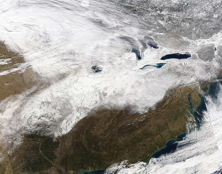
On February 6, 2022, the skies had cleared enough to permit the Moderate Resolution Imaging Spectroradiometer (MODIS) on board NASA’s Aqua satellite to capture a true-color image of a portion of the aftermath of the storm.
Summary
edit.jpg&action=edit§ion=1)
| Description |
English: A fierce winter storm left a swath of snow and ice from southern Texas to northern Maine—roughly two thousand miles (3,220 km)—in early February 2022. The complex event was created by the clash of a large arctic air mass that swept southeastward across the United States from Canada and a warm, humid mass of air that moved northwestward over the southeastern states. When the two extreme masses of air collided, ice and snow formed—and lots of it. Reports of ice up to .75 inches (1.9 cm) thick were recorded from places as diverse as Bonham, Texas, Atoka, Tennessee and Wyalusing, Pennsylvania. According to The Weather Channel, heaviest ice came in at 0.80 inches (2.0 cm) in Lake Ariel, a town in northeastern Pennsylvania. The storm didn’t slack on snow, either. Accumulations measured in feet in many locations, but the snow-total winner was Taos Ski Valley, New Mexico where 37 inches (94 cm) of fresh snow fell. Other major snow totals included Colorado Springs, Colorado, with 22 inches (56 cm) and Leiters Ford, Indiana, with 17 in (43 cm). The precipitation and strong winds snarled traffic, closed roads, caused hundreds of flight cancellations, and widespread power outages.
On February 6, 2022, the skies had cleared enough to permit the Moderate Resolution Imaging Spectroradiometer (MODIS) on board NASA’s Aqua satellite to capture a true-color image of a portion of the aftermath of the storm. Snow can be seen from eastern North Dakota to western Vermont, and as far south as eastern Texas. The storm began on February 1 and finally moved over the Atlantic Ocean on February 5. |
||
| Date | Taken on 6 February 2022 | ||
| Source |
Swath of Snow and Ice across the U.S. (direct link)
|
||
| Author | MODIS Land Rapid Response Team, NASA GSFC |
| This media is a product of the Aqua mission Credit and attribution belongs to the mission team, if not already specified in the "author" row |
Licensing
edit.jpg&action=edit§ion=2)
| This file is in the public domain in the United States because it was solely created by NASA. NASA copyright policy states that "NASA material is not protected by copyright unless noted". (See Template:PD-USGov, NASA copyright policy page or JPL Image Use Policy.) | ||
 |
Warnings:
|
File history
Click on a date/time to view the file as it appeared at that time.
| Date/Time | Thumbnail | Dimensions | User | Comment | |
|---|---|---|---|---|---|
| current | 22:18, 9 January 2024 | | 5,884 × 4,622 (4.21 MB) | OptimusPrimeBot (talk | contribs) | #Spacemedia - Upload of http://modis.gsfc.nasa.gov/gallery/images/image02082022_500m.jpg via Commons:Spacemedia |
You cannot overwrite this file.
File usage on Commons
There are no pages that use this file.
.jpg&oldid=840282769)