File:Switzerland-00149 - Hans Waldmann (18618318734).jpg
Original file (4,000 × 6,000 pixels, file size: 18.92 MB, MIME type: image/jpeg)
Captions
Captions
Summary edit
.jpg&action=edit§ion=1)
| Description |
English: PLEASE, NO invitations or self promotions, THEY WILL BE DELETED. My photos are FREE to use, just give me credit and it would be nice if you let me know, thanks.
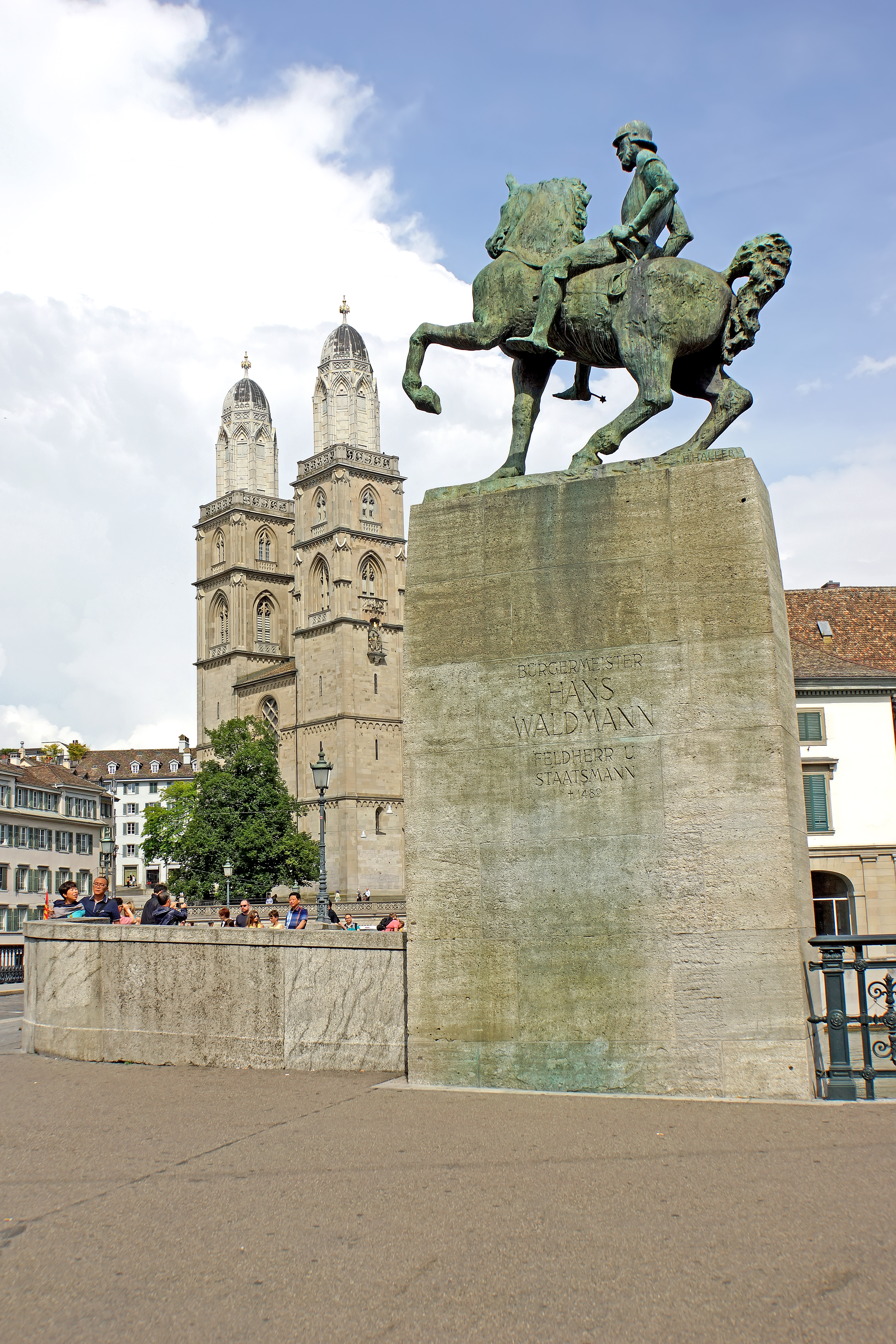
Hans Waldmann (1435 – 6 April 1489) was mayor of Zurich and Swiss military leader. Waldmann in the Burgundian Wars defeated Charles the Bold with an army estimated at 12,000 men. As mayor of Zurich, he sought to impose higher taxes on neighboring rural villages which, led to a peasant revolt. 500 peasants from Knonau toppled Waldmann as mayor in 1489. He was beheaded on April 6, 1489 following accusations of financial corruption, foreign connections and sodomy. The equestrian monument in front of the Fraumünster was unveiled on 6 April 1937, aiming to rehabilitate Waldmann who some say was the victim of a judicial murder. It was the subject of controversy for artistic reasons, deemed by conservative critics as being overly modern for the historical city centre. In the background is the Grossmünster is a Romanesque-style Protestant church. The present building near the banks of the Limmat River was constructed on the site of a Carolingian church, which was, according to legend, originally commissioned by Charlemagne. Construction of the present structure commenced around 1100 and it was inaugurated around 1220. According to legend, the Grossmünster was founded by Charlemagne, whose horse fell to its knees over the tombs of Felix and Regula, Zürich's patron saints. The legend helps support a claim of seniority over the Fraumünster, which was founded by Louis the German, Charlemagne's grandson. Recent archaeological evidence confirms the presence of a Roman burial ground at the site. |
| Date | |
| Source | Switzerland-00149 - Hans Waldmann |
| Author | Dennis Jarvis from Halifax, Canada |
| Permission (Reusing this file) |
Quote from photographer on numerous files
Quote from photographer on numerous files
|
| Camera location | | View this and other nearby images on: OpenStreetMap |
|---|
.jpg¶ms=047.372445_N_0008.542170_E_globe:Earth_type:camera_source:Flickr_&language=en)
Licensing edit
.jpg&action=edit§ion=2)
- You are free:
- to share – to copy, distribute and transmit the work
- to remix – to adapt the work
- Under the following conditions:
- attribution – You must give appropriate credit, provide a link to the license, and indicate if changes were made. You may do so in any reasonable manner, but not in any way that suggests the licensor endorses you or your use.
- share alike – If you remix, transform, or build upon the material, you must distribute your contributions under the same or compatible license as the original.
| This image was originally posted to Flickr by archer10 (Dennis) 117M Views at https://flickr.com/photos/22490717@N02/18618318734 (archive). It was reviewed on 2 March 2018 by FlickreviewR 2 and was confirmed to be licensed under the terms of the cc-by-sa-2.0. |
File history
Click on a date/time to view the file as it appeared at that time.
| Date/Time | Thumbnail | Dimensions | User | Comment | |
|---|---|---|---|---|---|
| current | 18:48, 2 March 2018 | | 4,000 × 6,000 (18.92 MB) | Artix Kreiger 2 (talk | contribs) | Transferred from Flickr via Flickr2Commons |
You cannot overwrite this file.
File usage on Commons
There are no pages that use this file.
.jpg&oldid=733301689)