File:Szastarka (gmina) location map.png

Original file (852 × 821 pixels, file size: 142 KB, MIME type: image/png)
Captions
Captions
Summary
edit_location_map.png&action=edit§ion=1)
| Description |
English: Location map |
| Date | |
| Source | Own work |
| Author | Smat |
| Description |
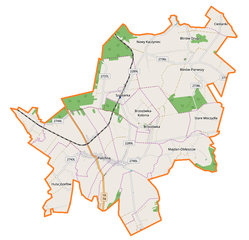
Polski: Mapa gminy Szastarka, Polska
English: Map of Szastarka (gmina), Poland |
|||||||||
| Date | ||||||||||
| Source | You may find a page on the OpenStreetMap wiki page for Szastarka (gmina) | |||||||||
| Creator |
OpenStreetMap contributors OpenStreetMap contributors |
|||||||||
| Permission (Reusing this file) |
OpenStreetMap data is available under the Open Database License (details). Map tiles are licensed under the Creative Commons Attribution-ShareAlike 2.0 license (CC-BY-SA 2.0).
This file is licensed under the Creative Commons Attribution-Share Alike 2.0 Generic license.
|
|||||||||
| Geotemporal data | ||||||||||
| Bounding box |
|
|||||||||
| Georeferencing | If inappropriate please set warp_status = skip to hide. | |||||||||
Licensing
edit_location_map.png&action=edit§ion=2)
| This work contains information from OpenStreetMap, which is made available under the Open Database License (ODbL).
The ODbL does not require any particular license for maps produced from ODbL data. Prior to 1 August 2020, map tiles produced by the OpenStreetMap Foundation were licensed under the CC-BY-SA-2.0 license. Maps produced by other people may be subject to other licences. |
File history
Click on a date/time to view the file as it appeared at that time.
| Date/Time | Thumbnail | Dimensions | User | Comment | |
|---|---|---|---|---|---|
| current | 08:16, 13 September 2017 | | 852 × 821 (142 KB) | Smat (talk | contribs) | User created page with UploadWizard |
You cannot overwrite this file.
File usage on Commons
There are no pages that use this file.
File usage on other wikis
The following other wikis use this file:
- Usage on pl.wikipedia.org
- Szastarka (gmina)
- Blinów Drugi
- Blinów Pierwszy
- Brzozówka-Kolonia
- Cieślanki
- Huta Józefów (województwo lubelskie)
- Majdan-Obleszcze
- Polichna
- Szastarka (wieś)
- Stare Moczydła
- Wojciechów-Kolonia
- Brzozówka (województwo lubelskie)
- Rzeczyca-Kolonia (powiat kraśnicki)
- Wojciechów (powiat kraśnicki)
- Nowy Kaczyniec
- Parafia św. Maksymiliana Kolbe w Hucie Józefów
- Szastarka (stacja kolejowa)
- Parafia św. Jana Marii Vianneya w Polichnie
- Polichna Kraśnicka
- Rzeczyca Kolonia (przystanek kolejowy)
- Parafia św. Maksymiliana Kolbego w Szastarce
- Podlesie (gmina Szastarka)
- Szastarka (osada)
- Blinów-Kolonia
- Blinów Pierwszy (kolonia)
- Parafia św. Jana Chrzciciela w Blinowie
- Parafia Zmartwychwstania Pańskiego w Brzozówce
- Polichna Czwarta
- Polichna Druga
- Polichna Pierwsza
- Polichna Trzecia
- Wypychów (Polichna)
- Moduł:Mapa/dane/Szastarka (gmina)
- Usage on pl.wikibooks.org
_location_map.png&oldid=708061421)