File:TAAC2009Map.png
Size of this preview: 799 × 156 pixels. Other resolution: 1,172 × 229 pixels.
Original file (1,172 × 229 pixels, file size: 23 KB, MIME type: image/png)
Captions
Captions
Add a one-line explanation of what this file represents
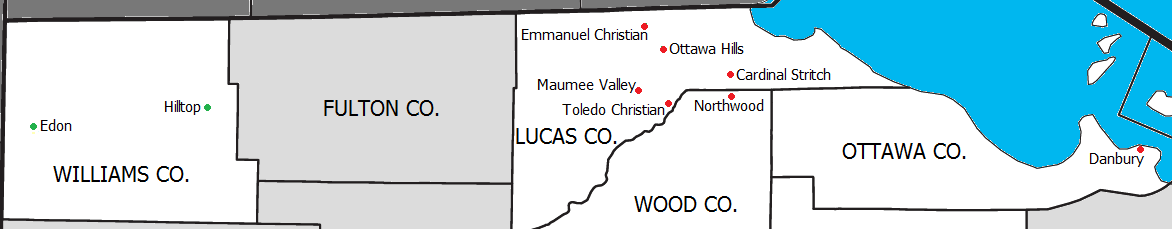
Summary
edit
| Description |
English: Map of the Toledo Area Athletic Conference |
| Date | |
| Source | http://ftp2.census.gov/geo/maps/general_ref/cousub_outline/cen2k_pgsz/oh_cosub.pdf |
| Author | 03:35, 20 September 2009 (UTC) |
Licensing
edit
This image or file is a work of a United States Census Bureau employee, taken or made as part of that person's official duties. As a work of the U.S. federal government, the image is in the public domain.
|
 |
Original upload log
edit
The original description page was here. All following user names refer to en.wikipedia.
| Date/Time | Dimensions | User | Comment |
|---|---|---|---|
| 2009-09-20 03:35 | 1172×229× (23886 bytes) | Frank12 | {{Information |Description = Map of the Toledo Area Athletic Conference |Source = http://ftp2.census.gov/geo/maps/general_ref/cousub_outline/cen2k_pgsz/oh_cosub.pdf |Date = 19 September 2009 |Author = ~~~~~ |Permission |
File history
Click on a date/time to view the file as it appeared at that time.
| Date/Time | Thumbnail | Dimensions | User | Comment | |
|---|---|---|---|---|---|
| current | 04:22, 25 April 2016 | 1,172 × 229 (23 KB) | FastilyClone (talk | contribs) | Transferred from enwp |
You cannot overwrite this file.
File usage on Commons
There are no pages that use this file.
File usage on other wikis
The following other wikis use this file:
- Usage on en.wikipedia.org