File:Tafelberg Deep Reef map.png
Size of this preview: 800 × 590 pixels. Other resolutions: 320 × 236 pixels | 640 × 472 pixels | 1,024 × 755 pixels | 1,280 × 944 pixels | 2,560 × 1,888 pixels | 3,000 × 2,212 pixels.
Original file (3,000 × 2,212 pixels, file size: 763 KB, MIME type: image/png)
Captions
Captions
Add a one-line explanation of what this file represents
Summary
edit
| Description |
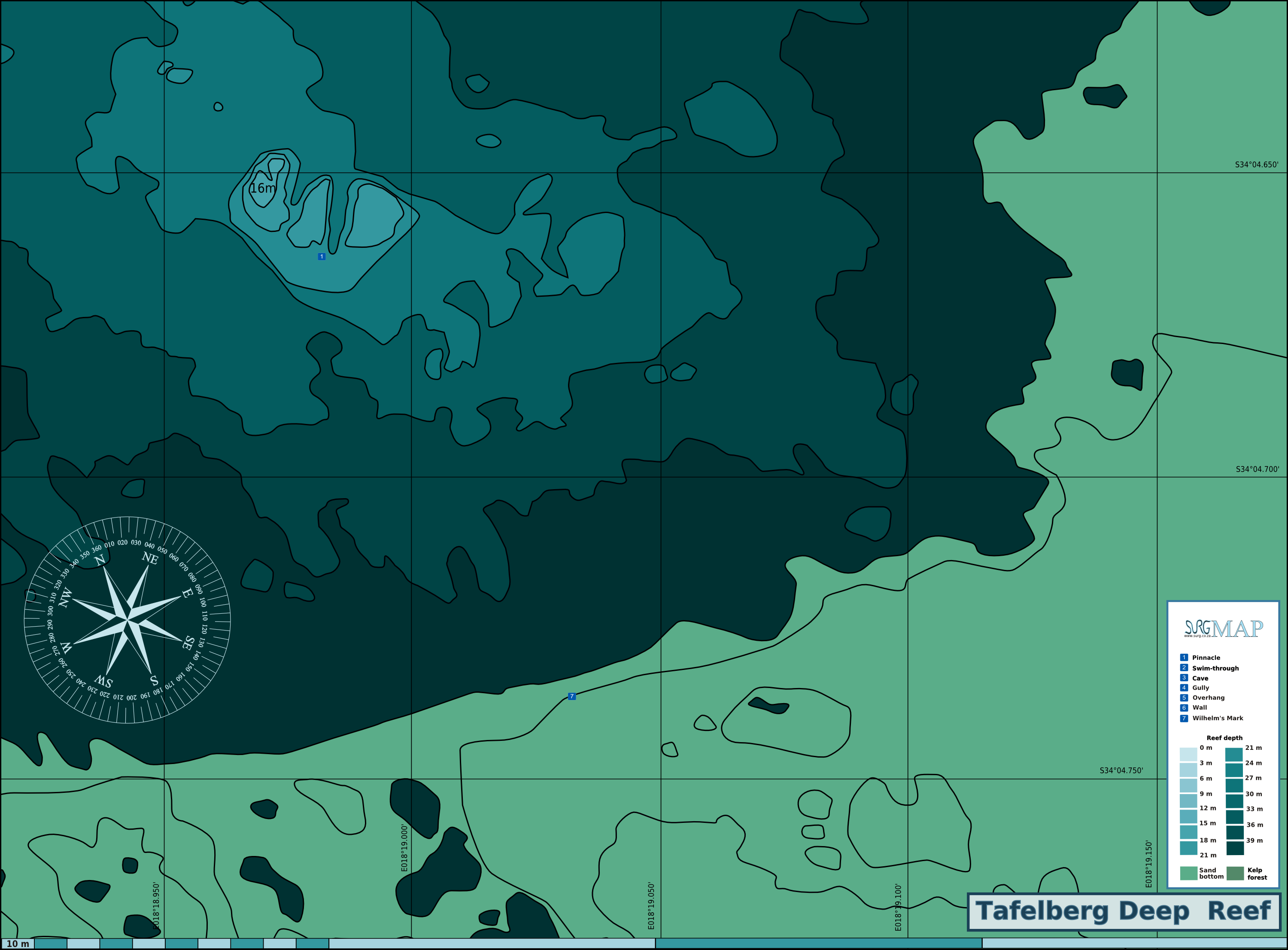
English: Map of the dive site at Tafelberg Deep Reef, Hout Bay, Cape Peninsula. |
| Date | |
| Source | Peter Southwood |
| Author | Peter Southwood |
Licensing
edit
User: (WT-shared) Pbsouthwood at wts wikivoyage, the copyright holder of this work, hereby publishes it under the following license:
This file is licensed under the Creative Commons Attribution-Share Alike 3.0 Unported license.
Attribution: User: (WT-shared) Pbsouthwood at wts wikivoyage
- You are free:
- to share – to copy, distribute and transmit the work
- to remix – to adapt the work
- Under the following conditions:
- attribution – You must give appropriate credit, provide a link to the license, and indicate if changes were made. You may do so in any reasonable manner, but not in any way that suggests the licensor endorses you or your use.
- share alike – If you remix, transform, or build upon the material, you must distribute your contributions under the same or compatible license as the original.
Original upload log
edit
| This file was imported from Wikivoyage WTS. |
The original description page was here. All following user names refer to wts.wikivoyage-old.
org:
- 2011-09-24 11:04 (WT-shared) Pbsouthwood[dead link] 3000×2212 (738217 bytes) {{Imagecredit|credit=Peter Southwood|captureDate=September 2011|location=Hout Bay, Cape Peninsula|source=Peter Southwood|caption=Map of the (Import from wikitravel.org/shared)
- 2011-09-24 11:48 (WT-shared) Pbsouthwood[dead link] 3000×2212 (758443 bytes) Latitude and longitue added to grid, Feature marked (Pinnacle and Wilhelm's mark) (Import from wikitravel.org/shared)
- 2011-10-17 15:19 (WT-shared) Pbsouthwood[dead link] 3000×2212 (784070 bytes) {{Imagecredit|credit=Peter Southwood|captureDate=September 2011|location=Hout Bay|source=Peter Southwood|caption=Map of the dive site at Taf (Import from wikitravel.org/shared)
- 2012-09-07 19:37 Pbsouthwood[dead link] 3000×2212 (781563 bytes) rm logo
File history
Click on a date/time to view the file as it appeared at that time.
| Date/Time | Thumbnail | Dimensions | User | Comment | |
|---|---|---|---|---|---|
| current | 01:24, 19 December 2012 | | 3,000 × 2,212 (763 KB) | OgreBot (talk | contribs) | (BOT): Reverting to most recent version before archival |
| 01:24, 19 December 2012 |  | 3,000 × 2,212 (766 KB) | OgreBot (talk | contribs) | (BOT): Uploading old version of file from wts.wikivoyage; originally uploaded on 2011-10-17 15:19:09 by (WT-shared) Pbsouthwood | |
| 01:24, 19 December 2012 |  | 3,000 × 2,212 (741 KB) | OgreBot (talk | contribs) | (BOT): Uploading old version of file from wts.wikivoyage; originally uploaded on 2011-09-24 11:48:47 by (WT-shared) Pbsouthwood | |
| 01:24, 19 December 2012 |  | 3,000 × 2,212 (721 KB) | OgreBot (talk | contribs) | (BOT): Uploading old version of file from wts.wikivoyage; originally uploaded on 2011-09-24 11:04:58 by (WT-shared) Pbsouthwood | |
| 19:33, 15 November 2012 |  | 3,000 × 2,212 (763 KB) | MGA73bot2 (talk | contribs) | {{BotMoveToCommons|wts.oldwikivoyage|year={{subst:CURRENTYEAR}}|month={{subst:CURRENTMONTHNAME}}|day={{subst:CURRENTDAY}}}} == {{int:filedesc}} == {{Information |description=Map of the dive site at Tafelberg Deep Reef. , Hout Bay, Cape Peninsula |date=... |
You cannot overwrite this file.
File usage on Commons
There are no pages that use this file.
File usage on other wikis
The following other wikis use this file:
- Usage on en.wikivoyage.org
- Usage on www.wikidata.org