File:Taka Atoll - Landsat N-59-10 2000 Image (1-100,000).jpg

Size of this preview: 800 × 555 pixels. Other resolutions: 320 × 222 pixels | 640 × 444 pixels | 1,024 × 710 pixels | 1,276 × 885 pixels.
Original file (1,276 × 885 pixels, file size: 46 KB, MIME type: image/jpeg)
Captions
Captions
Add a one-line explanation of what this file represents
Summary edit
.jpg&action=edit§ion=1)
| Description |
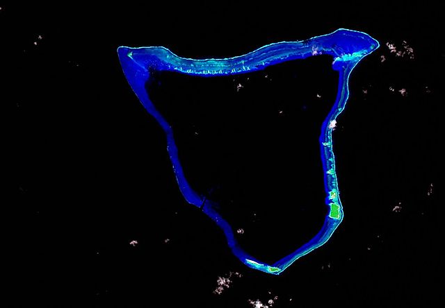
English: False color Landsat image of Taka (Toke), RMI, 2000. |
| Date | |
| Source | https://www.flickr.com/photos/evsmap/3230253297/sizes/o/in/set-72157613038641820/ |
| Author | Mr. Minton |
Licensing edit
.jpg&action=edit§ion=2)
This file is licensed under the Creative Commons Attribution 2.0 Generic license.
- You are free:
- to share – to copy, distribute and transmit the work
- to remix – to adapt the work
- Under the following conditions:
- attribution – You must give appropriate credit, provide a link to the license, and indicate if changes were made. You may do so in any reasonable manner, but not in any way that suggests the licensor endorses you or your use.
| This image, originally posted to Flickr, was reviewed on 20 July 2009 by the administrator or reviewer Abigor, who confirmed that it was available on Flickr under the stated license on that date. |
File history
Click on a date/time to view the file as it appeared at that time.
| Date/Time | Thumbnail | Dimensions | User | Comment | |
|---|---|---|---|---|---|
| current | 04:34, 19 July 2009 | | 1,276 × 885 (46 KB) | Cmholm (talk | contribs) | {{Information |Description={{en|1=False color Landsat image of Taka (Toke), RMI, 2000.}} |Source=http://www.flickr.com/photos/evsmap/3230253297/sizes/o/in/set-72157613038641820/ |Author=Mr. Minton |Date=2009-01-26 |Permission= |other_versions= }} [[Categ |
You cannot overwrite this file.
File usage on Commons
The following page uses this file:
File usage on other wikis
The following other wikis use this file:
- Usage on ast.wikipedia.org
- Usage on be.wikipedia.org
- Usage on ceb.wikipedia.org
- Usage on en.wikipedia.org
- Usage on en.wikivoyage.org
- Usage on es.wikipedia.org
- Usage on gl.wikipedia.org
- Usage on ig.wikipedia.org
- Usage on lt.wikipedia.org
- Usage on lv.wikipedia.org
- Usage on mk.wikipedia.org
- Usage on mt.wikipedia.org
- Usage on pl.wikipedia.org
- Usage on pt.wikipedia.org
- Usage on www.wikidata.org
- Usage on zh.wikipedia.org
.jpg&oldid=730178454)