File:Talajtextúravizsgálat Csongoron.PNG
No higher resolution available.
Talajtextúravizsgálat_Csongoron.PNG (405 × 223 pixels, file size: 16 KB, MIME type: image/png)
Captions
Captions
Add a one-line explanation of what this file represents
Summary
edit
| Description |
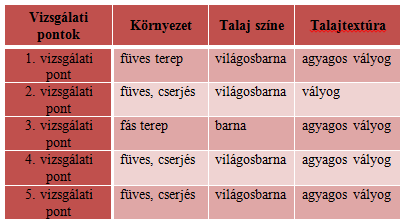
Magyar: A felső talajréteg-textúrák Csongor település különböző pontjain |
| Date | |
| Source | Own work |
| Author | Nagy Tibor |
Licensing
edit
| This chart is ineligible for copyright and therefore in the public domain, because it consists entirely of information that is common property and contains no original authorship. For more information, see Commons:Threshold of originality § Charts
|
File history
Click on a date/time to view the file as it appeared at that time.
| Date/Time | Thumbnail | Dimensions | User | Comment | |
|---|---|---|---|---|---|
| current | 19:25, 3 December 2013 | | 405 × 223 (16 KB) | Kmfhok (talk | contribs) | {{Információ | leírás = A felső talajréteg-textúrák Csongor település különböző pontjain | forrás = Saját szerkesztés | dátum = | helyszín = Csongor | szerző = Nagy Tibor | engedély = … |
You cannot overwrite this file.
File usage on Commons
There are no pages that use this file.
File usage on other wikis
The following other wikis use this file:
- Usage on hu.wikipedia.org