File:Tang-e Showgan (2968258757).jpg

Size of this preview: 800 × 600 pixels. Other resolutions: 320 × 240 pixels | 640 × 480 pixels | 1,024 × 768 pixels | 1,280 × 960 pixels | 2,560 × 1,920 pixels | 2,800 × 2,100 pixels.
Original file (2,800 × 2,100 pixels, file size: 1.39 MB, MIME type: image/jpeg)
Captions
Captions
Add a one-line explanation of what this file represents
Summary
edit| Description |
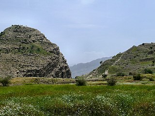
The Tang-e Showgan gorge seen from the site of the ancient sasanian city of Bishapour, builded by Emperor Shapur Ist, 3rd century CE. 2 fortifications used to kep the access of the gorge, builded on each cliff boearding the natural path: the Khale-ye Dokhtar (Virgin's fortress) on the right cliff, and a little one localy known as Khale-ye Pessar (The young man's fortress). 6 sassanian rock reliefs are carved in the valley were flows the Rud-e Shapur (Shapur's river). Taken at Bishapour, Viscinity of Kazerun, Fars province, Iran, April 2007. |
| Date | |
| Source | Tang-e Showgan |
| Author | dynamosquito from France |
| Other versions |
_(cropped).jpg)
.jpg&action=edit§ion=1)
| Camera location | | View this and other nearby images on: OpenStreetMap |
|---|
.jpg¶ms=029.772200_N_0051.568965_E_globe:Earth_type:camera_source:Flickr_&language=en)
Licensing
edit.jpg&action=edit§ion=2)
This file is licensed under the Creative Commons Attribution-Share Alike 2.0 Generic license.
- You are free:
- to share – to copy, distribute and transmit the work
- to remix – to adapt the work
- Under the following conditions:
- attribution – You must give appropriate credit, provide a link to the license, and indicate if changes were made. You may do so in any reasonable manner, but not in any way that suggests the licensor endorses you or your use.
- share alike – If you remix, transform, or build upon the material, you must distribute your contributions under the same or compatible license as the original.
| This image was originally posted to Flickr by dynamosquito at https://www.flickr.com/photos/25182210@N07/2968258757. It was reviewed on 10 May 2014 by FlickreviewR and was confirmed to be licensed under the terms of the cc-by-sa-2.0. |
File history
Click on a date/time to view the file as it appeared at that time.
| Date/Time | Thumbnail | Dimensions | User | Comment | |
|---|---|---|---|---|---|
| current | 17:48, 10 May 2014 | | 2,800 × 2,100 (1.39 MB) | Raso mk (talk | contribs) | Transferred from Flickr via Flickr2commons |
You cannot overwrite this file.
File usage on Commons
The following page uses this file:
.jpg&oldid=874996897)