File:Tanzania flood rufiji river on 20240429 labels.jpg
No higher resolution available.
Tanzania_flood_rufiji_river_on_20240429_labels.jpg (720 × 480 pixels, file size: 178 KB, MIME type: image/jpeg)
Captions
Captions
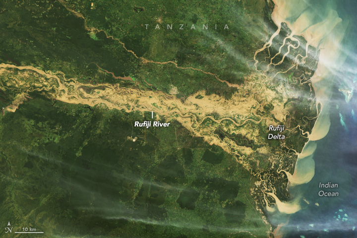
Satellite image of floods around Rufiji River in Tanzania on April 29, 2024
Summary edit
| Description |
Deutsch: Satellitenbild des über die Ufer getretenen Rufiji in Tansania am 29. April 2024
English: Satellite image of floods around Rufiji River in Tanzania on April 29, 2024 NASA Earth Observatory Image of the Day for May 2, 2024 |
| Date | |
| Source | https://earthobservatory.nasa.gov/images/152754/destructive-floods-afflict-tanzania |
| Author | NASA Earth Observatory images by Wanmei Liang, using Landsat data from the U.S. Geological Survey and MODIS data from NASA EOSDIS LANCE and GIBS/Worldview. |
Licensing edit
| This file is in the public domain in the United States because it was solely created by NASA. NASA copyright policy states that "NASA material is not protected by copyright unless noted". (See Template:PD-USGov, NASA copyright policy page or JPL Image Use Policy.) | ||
 |
Warnings:
|
File history
Click on a date/time to view the file as it appeared at that time.
| Date/Time | Thumbnail | Dimensions | User | Comment | |
|---|---|---|---|---|---|
| current | 11:52, 4 May 2024 | | 720 × 480 (178 KB) | Lupe (talk | contribs) | Uploaded a work by NASA Earth Observatory images by Wanmei Liang, using Landsat data from the U.S. Geological Survey and MODIS data from NASA EOSDIS LANCE and GIBS/Worldview. from https://earthobservatory.nasa.gov/images/152754/destructive-floods-afflict-tanzania with UploadWizard |
You cannot overwrite this file.
File usage on Commons
There are no pages that use this file.
File usage on other wikis
The following other wikis use this file:
- Usage on de.wikipedia.org