File:Tapovan from above Aditya Asopa.jpg

Size of this preview: 799 × 147 pixels. Other resolutions: 320 × 59 pixels | 640 × 118 pixels | 1,024 × 188 pixels | 1,280 × 236 pixels | 7,010 × 1,290 pixels.
Original file (7,010 × 1,290 pixels, file size: 1.21 MB, MIME type: image/jpeg)
Captions
Captions
Add a one-line explanation of what this file represents
Summary
edit
| Description |
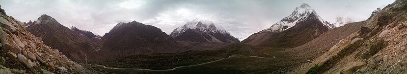
English: A panoramic bird's eye view of Tapovan above Gangotri glacier. The plain of Tapovan can be seen in the centre with the river Akash Ganga (आकाश गंगा ) flowing. The snow peaked mountains are Bhagirathi trio and Mt. Shivling (शिवलिंग पर्वत) with other smaller peaks around. This photo was taken from [30°55'13" N 79° 4' 43" E ] at 4478 meters above sea level. |
| Date | |
| Source | Own work |
| Author | Aditya.Asopa |
Licensing
edit
I, the copyright holder of this work, hereby publish it under the following license:
This file is licensed under the Creative Commons Attribution-Share Alike 4.0 International license.
- You are free:
- to share – to copy, distribute and transmit the work
- to remix – to adapt the work
- Under the following conditions:
- attribution – You must give appropriate credit, provide a link to the license, and indicate if changes were made. You may do so in any reasonable manner, but not in any way that suggests the licensor endorses you or your use.
- share alike – If you remix, transform, or build upon the material, you must distribute your contributions under the same or compatible license as the original.
File history
Click on a date/time to view the file as it appeared at that time.
| Date/Time | Thumbnail | Dimensions | User | Comment | |
|---|---|---|---|---|---|
| current | 07:33, 14 July 2017 | 7,010 × 1,290 (1.21 MB) | Aditya.Asopa (talk | contribs) | Cross-wiki upload from en.wikipedia.org |
You cannot overwrite this file.
File usage on Commons
There are no pages that use this file.
File usage on other wikis
The following other wikis use this file: