File:Tarso Toh.jpg
No higher resolution available.
Tarso_Toh.jpg (640 × 458 pixels, file size: 164 KB, MIME type: image/jpeg)
Captions
Captions
Add a one-line explanation of what this file represents
Summary edit
| Description |
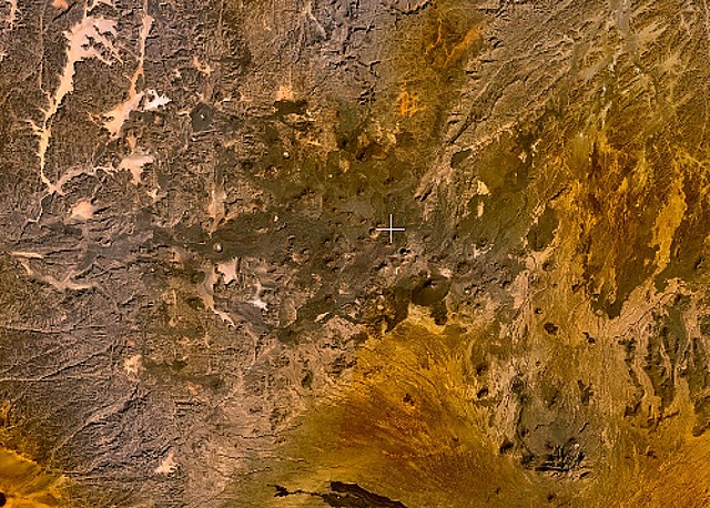
English: Small cinder cones and lava flows of the Tarso Tôh volcanic field can be seen in the large darker-brownish area at the center of this NASA Landsat image. This Pleistocene-to-Holocene volcanic field in the Tibesti Range of Chad covers a 30 x 80 km area and contains 150 scoria cones and two maars. Basaltic lava flows at Tarso Tôh were erupted over a basement of Precambrian schists and Paleozoic sandstones. The black lava flows at the very bottom-center are distal lava flows from Tarso Toussidé volcano. |
| Date | Unknown date |
| Source | http://www.volcano.si.edu/world/volcano.cfm?vnum=0205-009&volpage=photos&photo=119033 |
| Author | NASA Landsat7 image (worldwind.arc.nasa.gov) |
Licensing edit
| This image is in the public domain because it is a screenshot from NASA’s globe software World Wind using a public domain layer, such as Blue Marble, MODIS, Landsat, SRTM, USGS or GLOBE.
|
 |
File history
Click on a date/time to view the file as it appeared at that time.
| Date/Time | Thumbnail | Dimensions | User | Comment | |
|---|---|---|---|---|---|
| current | 23:28, 22 June 2010 | | 640 × 458 (164 KB) | Michael Metzger (talk | contribs) | {{Information |Description={{en|1=Small cinder cones and lava flows of the Tarso Tôh volcanic field can be seen in the large darker-brownish area at the center of this NASA Landsat image. This Pleistocene-to-Holocene volcanic field in the Tibesti Range o |
You cannot overwrite this file.
File usage on Commons
There are no pages that use this file.
File usage on other wikis
The following other wikis use this file:
- Usage on cs.wikipedia.org
- Usage on de.wikipedia.org
- Usage on en.wikipedia.org
- Usage on fa.wikipedia.org
- Usage on fr.wikipedia.org
- Usage on ru.wikipedia.org
- Usage on sk.wikipedia.org
- Usage on uk.wikipedia.org
- Usage on www.wikidata.org