File:Tarso Toussidé, Chad ESA23395159.tiff

Original file (7,615 × 4,893 pixels, file size: 213.23 MB, MIME type: image/tiff)
Captions
Captions
Summary
edit| Description |
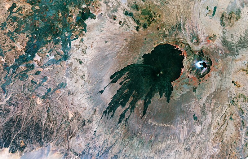
English: The Tarso Toussidé volcanic massif is featured in this false-colour composite image captured by the Copernicus Sentinel-2 mission. Zoom in to see this image at its full 10 m resolution or click on the circles to learn more about the features in it. Tarso Toussidé, capped by the Toussidé (potentially active) stratovolcano, is located in the western end of the Tibesti Mountains, in Chad. With an elevation of 3265 m above sea level, Toussidé is the second highest peak in Tibesti, after Emi Koussi. Toussidé has undergone a number of eruptions and lava flows, with the lava reaching lengths of 25 km and covering an area of 200 sq km, appearing to have ‘stained’ the ground in the process. The volcano ejected tephra, fragments of rock and volcano glass, lava and ash. In the middle of the field lies Pic Toussidé, a lava dome which can be seen poking out of the caldera. Toussidé is said to be amongst the youngest volcanoes in Tibesti. A large number of fumaroles (openings in or near a volcano through which gases emerge) are active on its summit, exhaling mostly water vapour at temperatures of 40–60 °C – suggesting it is the only active Tibesti volcano. Just next to Toussidé, in the far-right of the image, lies the Trou au Natron caldera, which sits at an elevation of around 2450 m. A number of volcanic cones sit on the floor of the caldera, with numerous vents and hot springs on the caldera’s floor emitting hot steam. Much of the surface of the caldera is lined with a white crust of salts, including sodium carbonite. These crusts are usually formed when mineral-rich steam is emitted from small vents on the crater’s floor, and when this evaporates in the heat, the minerals are left behind. The caldera has an irregular diameter of around 6-8 km and is up to 1000 m deep, and is said to have been filled by a freshwater lake during the last glacial maximum. In the left of the image, the red shows sparse vegetation along the ephemeral creeks. Satellite imagery is a practical way to study remote areas such as the volcanic regions in the Tibesti Mountain Range. The Copernicus Sentinel-2 mission carries a multispectral imager with 13 spectral bands and has a wide swath coverage, delivering data on Earth’s land every five days. This image, acquired on 21 September 2019, is also featured on the Earth from Space video programme. |
| Date | 23 July 2021 (upload date) |
| Source | Tarso Toussidé, Chad |
| Author | European Space Agency |
| Other versions |
|
| Activity | Observing the Earth |
| Mission | Sentinel-2 |
| Set | Earth observation image of the week |
| System | Copernicus |

Licensing
edit
|
This image contains data from a satellite in the Copernicus Programme, such as Sentinel-1, Sentinel-2 or Sentinel-3. Attribution is required when using this image.
Attribution: Contains modified Copernicus Sentinel data 2019
The use of Copernicus Sentinel Data is regulated under EU law (Commission Delegated Regulation (EU) No 1159/2013 and Regulation (EU) No 377/2014). Relevant excerpts:
Free access shall be given to GMES dedicated data [...] made available through GMES dissemination platforms [...].
Access to GMES dedicated data [...] shall be given for the purpose of the following use in so far as it is lawful:
GMES dedicated data [...] may be used worldwide without limitations in time.
GMES dedicated data and GMES service information are provided to users without any express or implied warranty, including as regards quality and suitability for any purpose. |
This media was created by the European Space Agency (ESA).
Where expressly so stated, images or videos are covered by the Creative Commons Attribution-ShareAlike 3.0 IGO (CC BY-SA 3.0 IGO) licence, ESA being an Intergovernmental Organisation (IGO), as defined by the CC BY-SA 3.0 IGO licence. The user is allowed under the terms and conditions of the CC BY-SA 3.0 IGO license to Reproduce, Distribute and Publicly Perform the ESA images and videos released under CC BY-SA 3.0 IGO licence and the Adaptations thereof, without further explicit permission being necessary, for as long as the user complies with the conditions and restrictions set forth in the CC BY-SA 3.0 IGO licence, these including that:
See the ESA Creative Commons copyright notice for complete information, and this article for additional details.
|
 | |
This file is licensed under the Creative Commons Attribution-ShareAlike 3.0 IGO license. Attribution: ESA, CC BY-SA IGO 3.0
| ||
File history
Click on a date/time to view the file as it appeared at that time.
| Date/Time | Thumbnail | Dimensions | User | Comment | |
|---|---|---|---|---|---|
| current | 09:22, 23 July 2021 |  | 7,615 × 4,893 (213.23 MB) | OptimusPrimeBot (talk | contribs) | #Spacemedia - Upload of https://esamultimedia.esa.int/img/2021/07/Tibesti_S2B_20190921_ML_crop_rotated.tif via Commons:Spacemedia |
You cannot overwrite this file.
File usage on Commons
The following page uses this file: