File:Tarumanagara id.svg

Size of this PNG preview of this SVG file: 512 × 260 pixels. Other resolutions: 320 × 163 pixels | 640 × 325 pixels | 1,024 × 520 pixels | 1,280 × 650 pixels | 2,560 × 1,300 pixels.
Original file (SVG file, nominally 512 × 260 pixels, file size: 204 KB)
Captions
Captions
Add a one-line explanation of what this file represents
Summary
edit| Description |
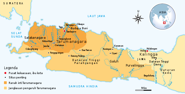
English: Kerajaan Tarumanagara, abad ke-4 sampai ke-7, kerajaan Hindu tertua di pulau Jawa |
| Date | |
| Source | Own work by uploader, see #References for references used creating the map. |
| Author | Gunawan Kartapranata |
| Other versions |
[]
|


|
This SVG file contains embedded text that can be translated into your language, using any capable SVG editor, text editor or the SVG Translate tool. For more information see: About translating SVG files. |
Licensing
edit
I, the copyright holder of this work, hereby publish it under the following licenses:
This file is licensed under the Creative Commons Attribution-Share Alike 3.0 Unported license.
- You are free:
- to share – to copy, distribute and transmit the work
- to remix – to adapt the work
- Under the following conditions:
- attribution – You must give appropriate credit, provide a link to the license, and indicate if changes were made. You may do so in any reasonable manner, but not in any way that suggests the licensor endorses you or your use.
- share alike – If you remix, transform, or build upon the material, you must distribute your contributions under the same or compatible license as the original.

|
Permission is granted to copy, distribute and/or modify this document under the terms of the GNU Free Documentation License, Version 1.2 or any later version published by the Free Software Foundation; with no Invariant Sections, no Front-Cover Texts, and no Back-Cover Texts. A copy of the license is included in the section entitled GNU Free Documentation License. |
You may select the license of your choice.
References
edit
Sumber yang digunakan untuk membuat peta ini:
- Munoz, Paul Michel (2006) Early Kingdoms of the Indonesian Archipelago and the Malay Peninsula, Singapore: Editions Didier Millet, pp. 104 ISBN: 9814155675.
File history
Click on a date/time to view the file as it appeared at that time.
| Date/Time | Thumbnail | Dimensions | User | Comment | |
|---|---|---|---|---|---|
| current | 15:14, 15 September 2016 | | 512 × 260 (204 KB) | Gunkarta (talk | contribs) | in Indonesian |
| 15:13, 15 September 2016 |  | 512 × 260 (203 KB) | Gunkarta (talk | contribs) | Enrichen with new sites | |
| 14:33, 2 January 2011 |  | 604 × 306 (202 KB) | Gunkarta (talk | contribs) | edit location of Kalingga | |
| 12:18, 12 November 2009 |  | 604 × 306 (200 KB) | Gunkarta (talk | contribs) | Correcting the capital "Sundapura" | |
| 14:56, 6 November 2009 |  | 604 × 306 (198 KB) | Gunkarta (talk | contribs) | {{Information |Description={{en|1=Kerajaan Tarumanagara, abad ke-4 sampai ke-7, kerajaan Hindu tertua di pulau Jawa}} |Source={{own}} |Author=Gunkarta Gunawan Kartapranata |Date=2009-11-06 |Permission= |other_versions= }} [[Category:Tar |
You cannot overwrite this file.
File usage on Commons
The following 2 pages use this file:
File usage on other wikis
The following other wikis use this file:
- Usage on id.wikipedia.org
- Usage on map-bms.wikipedia.org
- Usage on ms.wikipedia.org