File:Tavoywars.jpg
Size of this preview: 393 × 599 pixels. Other resolutions: 157 × 240 pixels | 602 × 918 pixels.
Original file (602 × 918 pixels, file size: 157 KB, MIME type: image/jpeg)
Captions
Captions
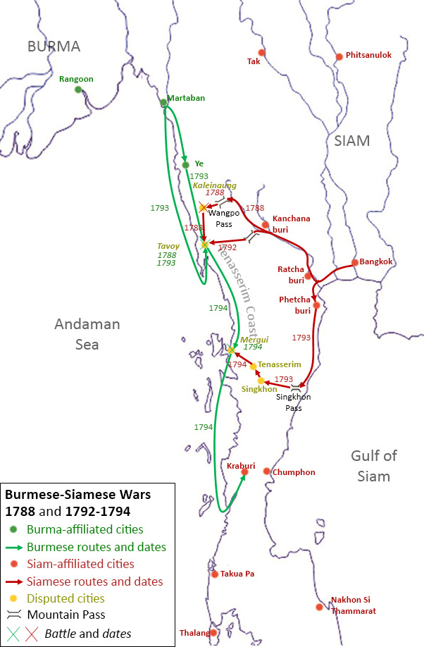
Map of Burmese-Siamese Wars over Tavoy in 1788 and 1792-1794
Summary edit
| Description |
English: Map of Burmese-Siamese Wars over Tavoy in 1788 and 1792-1794
Green represents Burmese cities and routes. Red represents Siamese cities and routes. Yellow represents the disputed Tenasserim Coast. |
| Date | |
| Source | Background outline taken and modified from d-maps.com. Other graphics, including texts, were added by the author. |
| Author | Biggie 943 845 39 |
Licensing edit
I, the copyright holder of this work, hereby publish it under the following license:
This file is licensed under the Creative Commons Attribution-Share Alike 4.0 International license.
- You are free:
- to share – to copy, distribute and transmit the work
- to remix – to adapt the work
- Under the following conditions:
- attribution – You must give appropriate credit, provide a link to the license, and indicate if changes were made. You may do so in any reasonable manner, but not in any way that suggests the licensor endorses you or your use.
- share alike – If you remix, transform, or build upon the material, you must distribute your contributions under the same or compatible license as the original.
File history
Click on a date/time to view the file as it appeared at that time.
| Date/Time | Thumbnail | Dimensions | User | Comment | |
|---|---|---|---|---|---|
| current | 12:59, 27 December 2020 | | 602 × 918 (157 KB) | NewFrontierHistoryEng (talk | contribs) | Uploaded own work with UploadWizard |
You cannot overwrite this file.
File usage on Commons
There are no pages that use this file.
File usage on other wikis
The following other wikis use this file:
- Usage on en.wikipedia.org
- Usage on th.wikipedia.org