File:Tees Barrage - geograph.org.uk - 1716352.jpg
No higher resolution available.
Tees_Barrage_-_geograph.org.uk_-_1716352.jpg (640 × 427 pixels, file size: 125 KB, MIME type: image/jpeg)
Captions
Captions
Add a one-line explanation of what this file represents
Summary
edit
| Description |
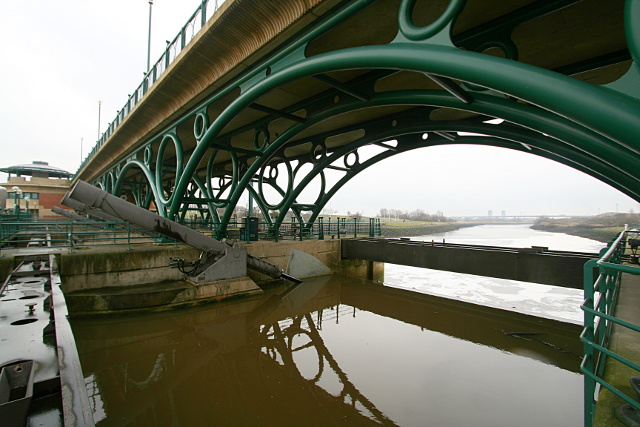
English: Tees Barrage The Tees Barrage was completed in 1995 as one of the Teesside Development Corporation's flagship projects. It's purpose was to maintain the water level of the River Tees upstream at 2.65m above Ordnance Datum, preventing polluted water moving upstream with every tide, and avoiding smelly mudbanks being uncovered twice daily over the 20km of previously tidal river up to Low Worsall. Construction began in November 1991 and was completed and opened in April 1995. The main part of the barrage as seen here comprises four 50-tonne fishbelly gates, each 13.5m long and 8m high and operated by a 21-tonne hydraulic ram. Water quality improvement upstream was a major project goal, but anyone who has made the error of capsizing whilst kayaking on the adjacent whitewater course will realise that there is still some way to go. |
| Date | |
| Source | From geograph.org.uk |
| Author | Andy Waddington |
| Attribution (required by the license) | Andy Waddington / Tees Barrage / |
| Camera location | | View this and other nearby images on: OpenStreetMap |
|---|
_heading:22.00&language=en)
| Object location | | View this and other nearby images on: OpenStreetMap |
|---|
_heading:22.00&language=en)
Licensing
edit

|
This image was taken from the Geograph project collection. See this photograph's page on the Geograph website for the photographer's contact details. The copyright on this image is owned by Andy Waddington and is licensed for reuse under the Creative Commons Attribution-ShareAlike 2.0 license.
|
This file is licensed under the Creative Commons Attribution-Share Alike 2.0 Generic license.
Attribution: Andy Waddington
- You are free:
- to share – to copy, distribute and transmit the work
- to remix – to adapt the work
- Under the following conditions:
- attribution – You must give appropriate credit, provide a link to the license, and indicate if changes were made. You may do so in any reasonable manner, but not in any way that suggests the licensor endorses you or your use.
- share alike – If you remix, transform, or build upon the material, you must distribute your contributions under the same or compatible license as the original.
File history
Click on a date/time to view the file as it appeared at that time.
| Date/Time | Thumbnail | Dimensions | User | Comment | |
|---|---|---|---|---|---|
| current | 09:37, 5 March 2011 | | 640 × 427 (125 KB) | GeographBot (talk | contribs) | == {{int:filedesc}} == {{Information |description={{en|1=Tees Barrage The Tees Barrage was completed in 1995 as one of the Teesside Development Corporation's flagship projects. It's purpose was to maintain the water level of the River Tees upstream at 2.6 |
You cannot overwrite this file.
File usage on Commons
There are no pages that use this file.