File:Teide2 copy.jpg
Size of this preview: 483 × 599 pixels. Other resolutions: 193 × 240 pixels | 387 × 480 pixels | 619 × 768 pixels | 1,096 × 1,359 pixels.
Original file (1,096 × 1,359 pixels, file size: 193 KB, MIME type: image/jpeg)
Captions
Captions
Add a one-line explanation of what this file represents
Summary
edit
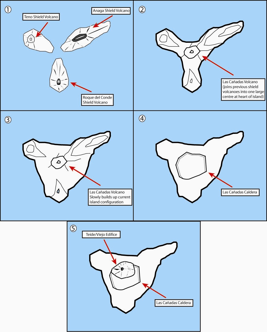
| Description | This is a very rough hand drawn schematic diagram of the formation of the island of Tenerife and evolution of the current Teide volcano. In step one the island began as three separate shield volcanoes - Anaga to the NE, Teno to the NW and Roque del Conde to the south. Step Two: After a period of erosion of the older massifs a new period of volcanic activity saw the creation of the large Las Canadas volcano. Step Three: The islands current shape begins to become apparent as Las Canadas grew. Step Four: The Las Canadas edifice collapsed to form the Las Canadas Caldera into which Step Five: The current Teide/Vierjo Central complex have grown. |
| Date | 8 October 2007, 22:33:57 (according to Exif data) |
| Source | Own work |
| Author | Fossiliferous |
Licensing
edit
I, the copyright holder of this work, hereby publish it under the following licenses:

|
Permission is granted to copy, distribute and/or modify this document under the terms of the GNU Free Documentation License, Version 1.2 or any later version published by the Free Software Foundation; with no Invariant Sections, no Front-Cover Texts, and no Back-Cover Texts. A copy of the license is included in the section entitled GNU Free Documentation License. |
This file is licensed under the Creative Commons Attribution 3.0 Unported license.
- You are free:
- to share – to copy, distribute and transmit the work
- to remix – to adapt the work
- Under the following conditions:
- attribution – You must give appropriate credit, provide a link to the license, and indicate if changes were made. You may do so in any reasonable manner, but not in any way that suggests the licensor endorses you or your use.
You may select the license of your choice.
File history
Click on a date/time to view the file as it appeared at that time.
| Date/Time | Thumbnail | Dimensions | User | Comment | |
|---|---|---|---|---|---|
| current | 20:13, 28 December 2008 | | 1,096 × 1,359 (193 KB) | Martin H. (talk | contribs) | try to repair it |
| 21:35, 8 October 2007 |  | 1,096 × 1,359 (736 KB) | ExtraFossiliferous (talk | contribs) | as before | |
| 21:32, 8 October 2007 |  | 1,644 × 2,039 (877 KB) | ExtraFossiliferous (talk | contribs) | as before | |
| 21:25, 8 October 2007 |  | 1,644 × 2,039 (1.39 MB) | ExtraFossiliferous (talk | contribs) | {{Information |Description=This is a very rough hand drawn schematic diagram of the formation of the island of Tenerife and evolution of the current Teide volcano. In step one the island began as three separate shield volcanoes - Anaga to the NE, Teno to | |
| 20:58, 8 October 2007 |  | 1,644 × 2,039 (1.39 MB) | ExtraFossiliferous (talk | contribs) | {{Information |Description=This is a very rough hand drawn schematic diagram of the formation of the island of Tenerife and evolution of the current Teide volcano. In step one the island began as three separate shield volcanoes - Anaga to the NE, Teno to |
You cannot overwrite this file.
File usage on Commons
There are no pages that use this file.
File usage on other wikis
The following other wikis use this file:
- Usage on fr.wikipedia.org