File:Temes ethnic map.png

Size of this preview: 403 × 599 pixels. Other resolutions: 161 × 240 pixels | 323 × 480 pixels | 516 × 768 pixels | 688 × 1,024 pixels | 1,768 × 2,629 pixels.
Original file (1,768 × 2,629 pixels, file size: 3.54 MB, MIME type: image/png)
Captions
Captions
Add a one-line explanation of what this file represents
Summary edit
| Description |
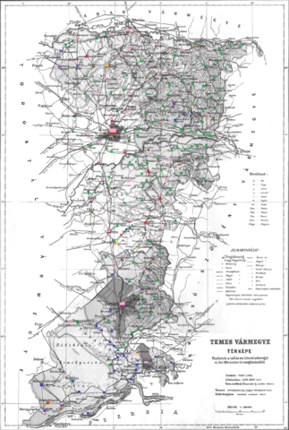
English: Ethnic map of the county (with data of the 1910 census). Key: dark green - Romanians; pink - Germans; dark blue - Serbs; red - Hungarians; light green - Czechs or Slovaks; light blue - Krashovani, yellow - Bulgarians; black - Roma. Coloured dots in plain rectangles imply the presence of smaller minority populations (generally more than 100 people or 10%). Multicoloured rectangles imply cities and villages with multi-ethnic populations with the order of the stripes following the ethnic composition of the settlement. |
| Date | |
| Source | Own work |
| Author | Zello |
Licensing edit
I, the copyright holder of this work, hereby publish it under the following license:
This file is licensed under the Creative Commons Attribution-Share Alike 4.0 International license.
- You are free:
- to share – to copy, distribute and transmit the work
- to remix – to adapt the work
- Under the following conditions:
- attribution – You must give appropriate credit, provide a link to the license, and indicate if changes were made. You may do so in any reasonable manner, but not in any way that suggests the licensor endorses you or your use.
- share alike – If you remix, transform, or build upon the material, you must distribute your contributions under the same or compatible license as the original.
File history
Click on a date/time to view the file as it appeared at that time.
| Date/Time | Thumbnail | Dimensions | User | Comment | |
|---|---|---|---|---|---|
| current | 15:41, 31 August 2016 | | 1,768 × 2,629 (3.54 MB) | Zello (talk | contribs) | User created page with UploadWizard |
You cannot overwrite this file.
File usage on Commons
The following page uses this file:
File usage on other wikis
The following other wikis use this file:
- Usage on ca.wikipedia.org
- Usage on en.wikipedia.org
- Usage on es.wikipedia.org