File:Tetela del Volcan localidades.svg

Size of this PNG preview of this SVG file: 800 × 554 pixels. Other resolutions: 320 × 221 pixels | 640 × 443 pixels | 1,024 × 709 pixels | 1,280 × 886 pixels | 2,560 × 1,771 pixels | 1,198 × 829 pixels.
Original file (SVG file, nominally 1,198 × 829 pixels, file size: 803 KB)
Captions
Captions
Add a one-line explanation of what this file represents
Summary
edit
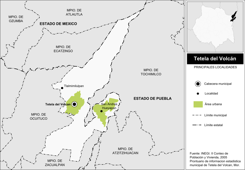
| Description | Mapa de localidades del Municipio de Tetela del Volcán en el estado de Morelos, México. |
| Date | |
| Source |
Own work This W3C-unspecified vector image was created with Inkscape . |
| Author | Battroid |
| Permission (Reusing this file) |
I, the copyright holder of this work, hereby publish it under the following license: This file is licensed under the Creative Commons Attribution-Share Alike 2.5 Generic license.
|
File history
Click on a date/time to view the file as it appeared at that time.
| Date/Time | Thumbnail | Dimensions | User | Comment | |
|---|---|---|---|---|---|
| current | 03:33, 10 October 2010 | | 1,198 × 829 (803 KB) | Battroid (talk | contribs) | == {{int:filedesc}} == {{Information| |Description=Mapa de localidades del Municipio de Tetela del Volcán en el estado de Morelos, México. |Source={{Own}} {{Inkscape}} |Date=2010-10-09 |Author=Battroid |Permission={{self|cc-by-sa-2.5}} |
You cannot overwrite this file.
File usage on Commons
There are no pages that use this file.
File usage on other wikis
The following other wikis use this file:
- Usage on es.wikipedia.org
- Usage on ru.wikipedia.org