File:Thailand (MODIS 2022-01-09).jpg

Size of this preview: 721 × 600 pixels. Other resolutions: 289 × 240 pixels | 577 × 480 pixels | 923 × 768 pixels | 1,231 × 1,024 pixels | 2,462 × 2,048 pixels | 4,305 × 3,581 pixels.
Original file (4,305 × 3,581 pixels, file size: 7.53 MB, MIME type: image/jpeg)
Captions
Captions
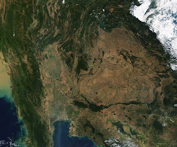
On January 6, 2022, the Moderate Resolution Imaging Spectroradiometer (MODIS) on board NASA’s Terra satellite acquired a true-color image of Thailand on a cloud-free day.
Summary
edit.jpg&action=edit§ion=1)
| Description |
English: Thailand is known for lush rainforests, stunning waterfalls, vast fields of rice, long coastlines, glittering cities, sacred spaces, and warm hospitality. Sitting in the center of the Indochinese Peninsula of Southeast Asia, the country is made up of 76 provinces and borders Myanmar (Burma) on the west, Laos in the east, Cambodia in the southeast, and Malaysia in the far south on the Malay Peninsula. The Gulf of Thailand washes the southern coastline, with the western coast of Thailand’s portion of the Malay Peninsula sitting on the Andaman Sea.
On January 6, 2022, the Moderate Resolution Imaging Spectroradiometer (MODIS) on board NASA’s Terra satellite acquired a true-color image of Thailand on a cloud-free day. The four natural regions of the country are clearly visible. The northern portion of Thailand are covered in mountains and spectacular forests, many of which are popular treks for residents and tourists alike. The Central Plains contain seemingly endless fields of rice and copious lakes and rivers. In the northeast, the land rises to a semi-arid plateau, which appears tan in this image. This is primarily agricultural land. The fourth natural region (which is not seen in this image) is the peninsular south, lined with beaches and off-shore islands. Also visible in this image is Bangkok, the most populous and capital city in Thailand. It can be seen as a large area of gray pixels sitting just inland of the northern shore of the Gulf of Thailand. |
||
| Date | Taken on 6 January 2022 | ||
| Source |
|
||
| Author | MODIS Land Rapid Response Team, NASA GSFC |
| This media is a product of the Terra mission Credit and attribution belongs to the mission team, if not already specified in the "author" row |
Licensing
edit.jpg&action=edit§ion=2)
| This file is in the public domain in the United States because it was solely created by NASA. NASA copyright policy states that "NASA material is not protected by copyright unless noted". (See Template:PD-USGov, NASA copyright policy page or JPL Image Use Policy.) | ||
 |
Warnings:
|
File history
Click on a date/time to view the file as it appeared at that time.
| Date/Time | Thumbnail | Dimensions | User | Comment | |
|---|---|---|---|---|---|
| current | 22:22, 9 January 2024 | | 4,305 × 3,581 (7.53 MB) | OptimusPrimeBot (talk | contribs) | #Spacemedia - Upload of http://modis.gsfc.nasa.gov/gallery/images/image01092022_250m.jpg via Commons:Spacemedia |
You cannot overwrite this file.
File usage on Commons
There are no pages that use this file.
.jpg&oldid=840282674)