File:The-Decapolis-map-HE.svg

Size of this PNG preview of this SVG file: 415 × 599 pixels. Other resolutions: 166 × 240 pixels | 332 × 480 pixels | 532 × 768 pixels | 709 × 1,024 pixels | 1,419 × 2,048 pixels | 519 × 749 pixels.
Original file (SVG file, nominally 519 × 749 pixels, file size: 115 KB)
Captions
Captions
Add a one-line explanation of what this file represents
Summary edit
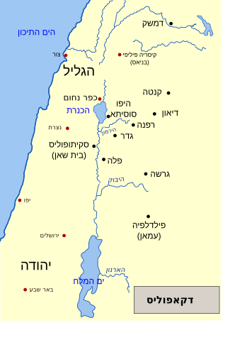
| Description | Depicted place: Decapolis |
| Date | |
| Source | Own work based on: The-Decapolis-map.svg |
| Author | Nichalp, Ori~ |
| Other versions |
[]
|


Licensing edit
This file is licensed under the Creative Commons Attribution-Share Alike 2.5 Generic license.
- You are free:
- to share – to copy, distribute and transmit the work
- to remix – to adapt the work
- Under the following conditions:
- attribution – You must give appropriate credit, provide a link to the license, and indicate if changes were made. You may do so in any reasonable manner, but not in any way that suggests the licensor endorses you or your use.
- share alike – If you remix, transform, or build upon the material, you must distribute your contributions under the same or compatible license as the original.
File history
Click on a date/time to view the file as it appeared at that time.
| Date/Time | Thumbnail | Dimensions | User | Comment | |
|---|---|---|---|---|---|
| current | 08:28, 21 July 2020 | | 519 × 749 (115 KB) | Asaf (WMF) (talk | contribs) | Corrected coloring of Damascus (which *was* part of the Decapolis) and Be'er-Sheva (which was not). |
| 22:00, 20 July 2020 |  | 519 × 749 (111 KB) | Ijon (talk | contribs) | Fixed another typo | |
| 21:47, 20 July 2020 |  | 519 × 749 (111 KB) | Ijon (talk | contribs) | Fixed typo. | |
| 14:38, 27 October 2009 |  | 519 × 749 (115 KB) | Ori~ (talk | contribs) | ed | |
| 14:36, 27 October 2009 |  | 519 × 749 (115 KB) | Ori~ (talk | contribs) | ed | |
| 14:35, 27 October 2009 |  | 519 × 749 (115 KB) | Ori~ (talk | contribs) | e | |
| 14:33, 27 October 2009 |  | 519 × 749 (115 KB) | Ori~ (talk | contribs) | ed | |
| 14:30, 27 October 2009 |  | 519 × 749 (115 KB) | Ori~ (talk | contribs) | ed | |
| 14:28, 27 October 2009 |  | 519 × 749 (115 KB) | Ori~ (talk | contribs) | {{Information |Description=דקאפוליס |Source=own after The-Decapolis-map.svg |Date=2009-10-27 |Author= Ori~ |Permission= |other_versions= }} {{cc-by-sa-2.5}} Category:Maps of the history of the Levant Category:Decapolis |
You cannot overwrite this file.
File usage on Commons
The following 16 pages use this file:
- User:Magog the Ogre/Multilingual legend/2020 July 11-20
- User:Magog the Ogre/Multilingual legend/2020 July 21-31
- File:Dekapol mapka.png
- File:The-Decapolis-map-HE.svg
- File:The-Decapolis-map-es.svg
- File:The-Decapolis-map-pt.svg
- File:The-Decapolis-map.fr.svg
- File:The-Decapolis-map.svg
- File:The-Decapolis-map el.svg
- File:The-Decapolis-map fi.svg
- File:The-Decapolis-map hu.svg
- File:The-Decapolis-map ru.svg
- File:The Decapolis Map.png
- File:Thedecapolis-ar.png
- File:Thedecapolis.png
- Template:Other versions/Decapolis
File usage on other wikis
The following other wikis use this file: